Tennessee
Looking for the best photography in Tennessee? We've got you covered with the top trails, trips, hiking, backpacking, camping and more around Tennessee. The detailed guides, photos, and reviews are all submitted by the Outbound community.
Top Photography Spots in and near Tennessee
-
Lancing, Tennessee
Camp at OBED Wild and Scenic River Area via the Point Trail
4 miYou will want to park at the Lilly Bluff parking lot. Your GPS won't know where this is, so here are the GPS coordinates N36° 06.162', W84° 43.280'.The trailhead is located on the North side of the parking lot. All you need to do is follow the sign for Point Trail. The trail culminates at an e...Read more -
Tellico Plains, Tennessee
Explore North River Road
4.7If you're looking to get off the beaten path and take the road less traveled, North River Road is your ticket to solitude.A popular loop for the locals is starting on Tellico River Road, then getting on North River Road to make your way up the mountain all the way to the Cherohala Skyway. Take th...Read more -
661-799 Stone Fort Drive, Tennessee
Hike Old Stone Fort Trail
5.02.9 mi / 265 ft gainThe main hiking trail at this small state park follows the wall of Old Stone Fort which was used by the Native Americans as a ceremonial gathering place. The trail threads through dramatic scenery where you can see the original entrance of the fort which was designed to face the exact spot on the...Read more -
Hampton, Tennessee
Hike to Laurel Fork Falls
4.62.6 mi / 600 ft gainFrom Hampton, Tennessee, take US-321S for about 3.5 miles. Turn right onto Dennis Cove Road and travel for 4 miles on this steep and very curvy mountain road. The trailhead is where the Appalachian Trail (AT) crosses the road at a small gravel lot on the left. Take the AT north on the trail lea...Read more -
Gatlinburg, Tennessee
Hike to Clingman’s Dome via Newfound Gap
4.516.6 mi / 1600 ft gainThis route to Clingmans Dome is available throughout the year. But during the winter months from December 1 through March 31, the 7-mile Clingman’s Dome Road that branches off Highway 441 at Newfound Gap, stays closed. This means the usual drive to the parking area located just a half mile below ...Read more -
Grandview, Tennessee
Hike to Piney Falls
5.01.5 mi / 500 ft gainThe gravel road heading to the trailhead is on the rougher side to take it slow. When you get to the trailhead it’s a small gravel pull off right off the road. There are no maps at the trailhead but there are only a few trails to take and they are marked with a blue marker. To get to the upper fa...Read more -
Altamont, Tennessee
Hike the Falls Loop Trail in South Cumberland State Park
4.53.2 mi / 500 ft gainNestled in the Savage Gulf State Natural Area, the popular Falls Loop Trail begins across from the Greeter Falls parking lot. At 0.4 miles into the hike you'll reach a fork in the trail, take the left route towards Boardtree Falls. Right before reaching the waterfall you'll come upon a suspension...Read more -
Hampton, Tennessee
Hike and Traverse the Cables to Dennis Cove Falls
5.03.2 mi / 300 ft gainThe Hike to Dennis Cove Falls includes three water crossings and passes several small waterfalls. Sturdy cables spanning the width of the water crossings provide a fun way of traversing the creek without wading. It is completely possible to wade through the creek while holding onto the cables for...Read more -
Lewisburg, Tennessee
Canoe down the Duck River
4.3Start this canoe adventure from Milltown Dam for an easy five-mile paddle down a wide, scenic river. During the warmer months, you will undoubtebly encounter a variety of wildlife, from water to land. Take your time as you float around small islands and rocks, and dock your boat for a quiet picni...Read more -
U.S. 441, Tennessee
Photograph the Smokies from Morton Overlook
4.3The Morton Overlook is one of the Great Smoky Mountains National Parks most well known and visited overlooks. Morton offers a wide view of the Great Smoky Mountains and is a perfect spot for some really good photography opportunities. Coming from Gatlinburg, TN it is roughly 13 miles from the vis...Read more -
Jamestown, Tennessee
Twin Arches Loop
1.22 mi / 177 ft gainThe trail starts at the parking lot which has some nice bathrooms and a nice small picnic area that is open year-round. From the trailhead, you will follow the signs that will lead you to a short mostly flat, 7-mile hike to the first arch. Once you get to the first arch there is a small area with...Read more -
Scenic Loop Road, Tennessee
Hike to the Base of Fall Creek Falls
5.00.86 mi / 299 ft gainFall Creek Falls State Park hosts a variety of large waterfalls which can easily become confusing. The park's main attraction is the 256 foot waterfall dubbed "Fall Creek Falls." Fall Creek Falls is observable from a viewing platform less than a five minute walk from the Scenic Loop Road parking ...Read more -
Oneida, Tennessee
Backpack to Angel Falls Overlook in the Big South Fork
4.06.4 mi / 800 ft gainStarting at a very small parking space, you head onto a fairly overgrown trail for half a mile. The trail then begins to thin out and is not as overgrown. Keeping a steady incline, you almost instantly feel the burn in your calves. At around 2 miles in, there is a single grave from a baby that l...Read more -
Unicoi, Tennessee
Pinnacle Mountain Fire Tower via Fire Tower Road
5.03.47 mi / 663 ft gainPinnacle Mountain hosts one of the nicest fire towers on the East Coast of the United States. The fire tower is relatively new, sturdy, and has a large 360 degree viewing area at the top. The tower overlooks the Downtown Johnson City area, Elizabethton, Erwin, and the rest of the Buffalo Mountain...Read more -
Benton, Tennessee
Take in the View at Chilhowee Overlook
5.0Catch the sunset, bring friends and a picnic, or gaze at the stars from this classic Tennessee overlook! To reach Chilhowee Overlook, follow U.S. Highway from Ocoee, Tennessee for 8 miles then turn left onto Oswald Road. Follow Oswald Road for 3.75 miles until you encounter the overlook on your r...Read more -
Lancing, Tennessee
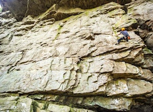
Climb The Lilly Bluff Wall
The Obed Wild and Scenic River is typically not found in the same conversations as Zion or Yosemite, but be assured this hidden gem of Tennessee is one of the East Coast's must climb destinations.There are a number of climbing areas within the Obed worth exploring, ranging from bouldering to mul...Read more

