Carlsbad Caverns National Park, New Mexico
Top Spots in and near Carlsbad Caverns National Park
-
Carlsbad, New Mexico
Climb Down into the Depths of Carlsbad Caverns
5.01.2 mi / -2000 ft gainThe Carlsbad Caverns is an experience like no other. There is a seven mile scenic road that leads into the park, which will direct you towards the ranger station and entrance to the caves. The entrance to this road starts and ends in Whites City.You have two options to enter the cave: The first i...Read more -
Carlsbad, New Mexico
Tour the Left Hand Tunnel in the Carlsbad Caverns
The Carlsbad Caverns have a self-guided tour sections and a handful of guided tours you have to pay extra for. For $7 for adults and $3.50 for children, a park ranger puts on an act and even dresses the part of the late Jim White, founder of the Carlsbad Caverns, while taking you on an adventure...Read more -
Culberson County, Texas
McKittrick Canyon Trail to McKittrick Ridge Campground
5.014.27 mi / 3274 ft gainThis hike is not for the faint of heart or the out of shape. Bolstering 2000ft of elevation gain over 10 miles of rough terrain, this hike will challenge you but grant you an immense reward if you can persevere. Make sure you've packed plenty of water. There are NO backcountry water supply points...Read more -
Culberson County, Texas
Pratt Lodge Via McKittrick Canyon Trail
4.8 mi / 341 ft gainPratt Lodge via McKittrick Canyon Trail is a 4.8 mile out and back hike that takes you by a river located near Salt Flat, TX.Read more -
Culberson County, Texas
Smith Springs Loop
5.02.49 mi / 400 ft gainParked at the trail head of Frijoles Ranch. Started my hike on the paved trail to Manzanita springs. After that the trail winds trough desert landscape with numerous desert wildflowers in the early fall, The trail ends up at the base of the mountains where I saw the springs. Returned to the park...Read more -
31.893785,-104.822339
Pinery Trail
3.01.0 miPark at the visitor center and start to walk the trail located at the north end of the visitor center. The trail is easy to walk and has very good views of the Park. There are a great variety of wildflowers along the trail during the summer. At the end of the trail you can explore the ruins of th...Read more -
Culberson County, Texas
Hunter Peak Loop
8.13 mi / 2546 ft gainFrom Pine Springs Trailhead follow Tejas Trail (3.7 miles), then take the Bowl Trail counter-clockwise (.9) until the Hunter Mountain spur trail (.1 each way). Then it's back on the Bowl Trail until you reach the start of the Bear Canyon Trail (.5). Descend along switchbacks (1.8 miles) and take ...Read more -
Culberson County, Texas
Guadalupe Peak Trail
4.78.15 mi / 2867 ft gainThe Hike This nearly 8.2-mile out-and-back hike starts almost a mile above sea level and has more than 2,800 feet of elevation gain. The beginning 1.5 miles include a lot of switchbacks, and hikers quickly gain elevation. The second part of the trail up the North-facing slope is shady as it goes...Read more -
Culberson County, Texas
El Capitan in Guadalupe Mountain NP
8.14 mi / 1100 ft gainThe route to the summit of El Capitan starts from the Guadalupe Peak trail some 300ft below the summit where you can first see the full vista of El Capitan stretching out before you. There is no trail to the peak, so you will have to navigate and find the best route possible. There are four prom...Read more -
Culberson County, Texas
Devil's Hall Trail
5.03.85 mi / 692 ft gainStart your hike from the campground area. There are several trailheads there. Hike for about a mile through some forested and cacti covered area with great views of the river valley and the Permian reef. After the first mile the trail descents into a wash and you can follow the wash doing some ...Read more -
1300 East Williams Road, Texas
Hike the Salt Basin Dunes Trail
4.03 mi / 200 ft gainAfter the drive from Dell City park at the parking lot at the end of Williams rd. Start walking the trail towards the dunes. It is a 3 mile round trip. You can hike around the dunes and enjoy the views of the Guadalupe Mountains and the surrounding dunes . Best time to visit is during the cooler ...Read more -
Hudspeth County, Texas
Gypsum Sand Dunes, Guadalupe Mountains NP
5.03.01 mi / 50 ft gainTo get there, first talk to park ranger at the Pine Springs Visitor Center. There is a gate that you may need to borrow a key for. You will need to actually drive out of the park to get to the gypsum dunes, leaving and heading west on 62/180 for 14 miles and then take a right (head north) on priv...Read more
Top Activities
Camping and Lodging in Carlsbad Caverns National Park

Carlsbad, New Mexico
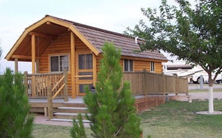
Carlsbad KOA Holiday
Kick back with family and friends at this beautiful desert oasis built in 2000. This award-winning KOA is big rig friendly: Most sites ar...


