Evergreen, Colorado
Top Spots in and near Evergreen
-
Littleton, Colorado
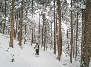
Snowshoe Deer Creek Canyon Park
5.1 mi / 1250 ft gainDeer Creek Canyon Park offers up to 13 miles of wind-sheltered trails perfect for enjoying after a fresh snow. The Plymouth Mountain Trail offers steep climbs and big views while Homesteader Trail offers the best forest scenery in the Denver area. The recommended route is Plymouth Creek Trail to ...Read more -
Littleton, Colorado
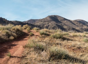
Hike the Meadowlark Plymouth Trail
4.06 mi / 1197 ft gainFrom the parking lot, you can take the Meadowlark trail to the west or the Plymouth Creek Trail to the southeast. It does not matter which trail you take because it ends up becoming loop. For a more gradual slope up the hill, take the Meadowlark trail. After a little more than a mile, it intersec...Read more -
Idaho Springs, Colorado
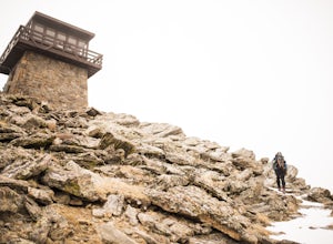
Squaw Mountain Fire Lookout
4.03.92 mi / 791 ft gainCome check out the Squaw Mountain Fire Lookout, a historic spot located in the Mount Evans Wilderness Area of Colorado, and one of the highest lookout towers in the country, at an elevation of 11,486 ft. Just a short drive from the Front Range corridor, you can hike/backpack in to this lookout ar...Read more -
Golden, Colorado
Hike the Golden Cliffs Trail
5.0From here, you can choose a few different hiking paths. This out-and-back trek starts at the trailhead up and to the left. Along the way you'll pass a bench dedicated to Craig Luebben — a writer, photographer and climbing guide. At this point, you probably haven't even broken a sweat yet. It's ti...Read more -
Golden, Colorado
Mountain Bike the North Table Mountain Loop
4.57.5 mi / 890 ft gainOnce you're parked, you can choose to ride this trail either counterclockwise or clockwise. My personal recommendation is CCW, which entails you head up the steep paved road on the east-southeast corner of the parking lot first. The climb is about 10 minutes of grunt work and then on to flat grou...Read more -
Idaho Springs, Colorado
Hike Chief Mountain, CO
4.54 mi / 1100 ft gainSitting at 11,709’, Chief Mountain is not one of Colorado’s highest peaks, but the views from this mountain are spectacular nonetheless and rival the views of any 14er I’ve climbed. This mountain sits along Squaw Pass Road so you get the luxury of a high trailhead for this peak.To get there, foll...Read more -
Golden, Colorado
Hike the North Table Mountain Loop
3.1 mi / 400 ft gainThe hike starts out from the North Table Mountain Park parking lot just east of Highway 93 on the North Table Loop Trail, with a half-mile fire road straight up the mountain. This fire road is by far the most strenuous part of the hike, and is essentially the sole elevation gain for the hike; onc...Read more -
Littleton, Colorado
Hike or Bike Hildebrand Ranch
4.05.1 mi / 324 ft gainHildebrand Ranch Park is often overshadowed by the other nearby Jeffco Parks, but for the few that it does attract the trails do not disappoint. The Two Brands Trail starts at about 5600ft just off of Deer Creek Canyon Rd. It is a relatively flat trail that tops out at about 5821ft making it a...Read more -
Littleton, Colorado
Hike the Eagle's View Trail
4.34.3 mi / 900 ft gainReynolds Park is part of the Jefferson County Open Space system. Located a few miles south of Conifer, off Hwy 285 on S. Foxton Road, it is a foothills park geared for families, groups, and the casual hiker. The network of trails on the west side of the road offers hikers and equestrians anything...Read more -
Golden, Colorado
Hike the Sawmill to Maverick Loop
4.32 mi / 450 ft gainFor this adventure, you'll be completing the Sawmill to Maverick loop. It is a short, but gentle trail that will take you through open meadows, to pine forests, and great views of Denver and Golden.Starting from the west parking area, cross the road and hit the Sawmill Trail. This trail starts ou...Read more -
Evergreen, Colorado
Photograph Ancient Bristlecone Pines on Mt. Goliath
5.0On the way to the summit of Mt. Evans sits a small 160 acre preserve of some of the world's oldest living trees. The Mount Goliath Natural Area protects a rare site of Bristlecone Pines that make excellent photographic subjects.Immediately after parking you're surrounded by a miniature forest ful...Read more -
Golden, Colorado
Hike Beaver Trail in Golden Gate Canyon State Park
2.3 mi / 1046 ft gainThis trail starts off at Slough Pond, a great fishing pond or picnic spot. The trail starts out tree-covered. After a few tenths of a mile you have the choice to go clockwise or counter-clockwise. If you go counter-clockwise you have about 3/4 of a mile of steep uphill hiking to do (the Park rate...Read more -
Evergreen, Colorado
Hike the Resthouse/Lincoln Lake Trail
4.5While the Mt. Evans Wilderness never has a shortage of visitors, thanks to its proximity to Denver, it is possible to find a more private hike if you know where to look. Lincoln Lake Trail, accessible from Echo Lake year-round, is not as glamorous as its sister trail, Chicago Lakes, but is a wond...Read more -
Golden, Colorado
Summit Windy Peak via the Burro Trail
4.06.35 mi / 1825 ft gainThe Burro Trail starts at the Bridge Creek Trailhead Parking Lot and leads off to the left. While this trail is incredibly well marked it wouldn't hurt to grab a map at the visitors center before you start! From the parking lot you'll travel along the trail for 0.7 miles until you reach your firs...Read more -
Golden, Colorado
Hike to Forgotten Valley
4.33.6 mi / 852 ft gainThere are over 35 miles of hiking trails in the park. The twelve trails in Golden Gate Canyon State Park are named after an animal and marked with the animal’s footprint.For a 2.6 round trip hike, start at the Burro Trailhead in Golden Gate Canyon State Park. You’ll immediately cross over a lit...Read more -
Golden, Colorado
Hike the Mountain Lion Trail
6.7 mi / 1230 ft gainThere are three parking lots with direct access to the Mountain Lion Trail. The main one is off of Crawford Gulch Road, but any of them are good starting points! This loop has pretty similar elevation gain and loss profiles no matter which way you go, so you can go any direction. This adventure ...Read more

