Moss Beach, California
Looking for the best photography in Moss Beach? We've got you covered with the top trails, trips, hiking, backpacking, camping and more around Moss Beach. The detailed guides, photos, and reviews are all submitted by the Outbound community.
Top Photography Spots in and near Moss Beach
-
Bolinas, California
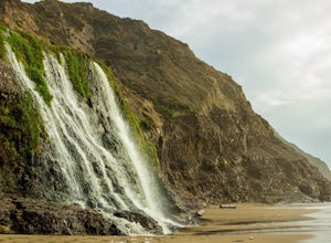
Alamere Falls via Palomarin Trailhead
4.513.54 mi / 1614 ft gainAlamere Falls is the tallest waterfall in the bay area. It is known as a tide fall because it empties directly into the Pacific Ocean. This is extremely unique because there are only 34 tide falls in the world and two in California, the other being McWay Falls in Big Sur. Enjoy stunning views of...Read more -
Fremont, California
Mission Peak via Hidden Valley Trail
4.26.16 mi / 2116 ft gainBreathtaking views of the Bay Area are your reward for making this climb to the top of Mission Peak. It’s a 3-mile trek to the top of the peak and then back down the same way. This is a moderate hike that provides a nice workout – so be prepared. Park at the Stanford Avenue entrance gate. There ...Read more -
Richmond, California
Explore Point Pinole Shoreline
5.0Point Pinole Regional Shoreline is a 2,315-acre parkland that juts out into the San Pablo Bay. Only a brief car ride from San Francisco, this is a great spot for a Sunday stroll, picnic or simply to find a quiet space.There are several short trails to choose from that wind through eucalyptus grov...Read more -
San Rafael, California
China Camp Loop
4.09.23 mi / 1716 ft gainPark at the lot in the China Camp State Park. Hop onto the Bay View trail to gain to begin the loop trail. Switchbacks take you up to a long and easy path passing through shaded and open areas. Enjoy the grasslands speckled with oak trees and coyote brush. You can see the San Rafael bay and bridg...Read more -
Davenport, California
Hike around Greyhound Beach and Climb Greyhound Rock
0.7 mi / 0 ft gainThe trailhead is at the Greyhound Rock State Marine Conservation Area which is directly off Highway 1. There is a large paved parking lot with a good amount of trees so finding a shady parking spot isn't that difficult (if that's important to you). The parking lot is located on the beach cliffs ...Read more -
San Geronimo, California
Roys Redwood Preserve Loop
5.02.37 mi / 430 ft gainRoy's Redwoods Preserve is an easily missed pocket of Redwoods off Nicasio Valley Road in Marin County. Don't miss it: heading North on Sir Francis Drake Blvd turn right onto Nicasio Valley Rd--the gate for this little park is about a half mile up on the right. From the main entrance you enter a ...Read more -
Novato, California
Buck Gulch Falls Trail
5.01.26 mi / 203 ft gainBuck Gulch Falls (also known as Fairway Falls) is an easy, scenic hike that takes you through a beautiful forest on your way to a 15-foot waterfall. This little neighborhood treasure is tucked away in Novato, CA at the end of Fairway Drive and there is ample parking near the trailhead. If you v...Read more -
Sunol, California
Little Yosemite via Canyon View Trail
4.03.01 mi / 705 ft gainPlease note this is a fragile ecosystem and watershed. There is NO swimming allowed in Alameda Creek and trespassing is prohibited on Water Department lands that are not accessible to the public. You can learn more about the restrictions and the area at ebparks.org. After entering the kiosk you...Read more -
Walnut Creek, California
Run the Mt. Diablo Foothill Loop
5.06.2 mi / 875 ft gainContinue by car down Castle Rock Road until it dead ends at the beginning of the trail. Parking is usually easy to find. If full, there is another overflow lot about 500 ft back the way you came in.You'll walk a good half mile down the trail before getting the main gate. As you're walking, you'll...Read more -
Point Reyes Station, California
Bear Valley to Coast Camp Loop
5.016.18 mi / 2818 ft gainPermit and Trail Camp Info To stay overnight in Point Reyes, you must stay at one of the Trail Camps. Camping anywhere else in the park is not allowed. Permits for the Trail Camps can be booked up to 6 months in advance. If you are looking to go on a weekend, then you'll want to start loo...Read more -
Danville, California
Hike in Mount Diablo's Madrone Canyon
2.8 mi / 550 ft gainThis hike starts at the Rock City area of Mount Diablo State Park. Begin at the Madrone Canyon Trail, hiking southeast towards the Devils Slide trail. Along this section of the hike, the trail dips into a wooded canyon and follows the path of a small creek. To best experience the beauty of the cr...Read more -
Walnut Creek, California
Camp at Juniper Campground in Mount Diablo SP
Mount Diablo's summit in Mount Diablo State Park rises to 3,848ft, with Juniper Campground in Mount Diablo SP is at approximately 3,000ft in elevation. Juniper Campground overlooks the valley below and some of the San Francisco Bay. Reservations for Juniper Campground can be made at Reserveamer...Read more -
Davenport, California
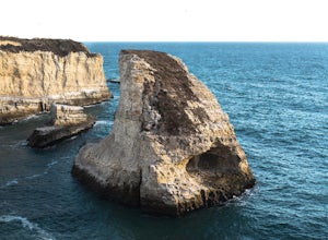
Beach Picnic at Shark Fin Cove
4.3Shark Fin Cove is a large rock formation in an inlet off Highway 1 in Northern California. It is located 1 mile south of Davenport and 10 miles north of Santa Cruz. There is a sizable parking lot located on the side of Highway 1 to park in. Walk down the path left of the parking lot and cross the...Read more -
Point Reyes Station, California
Hike the Laguna Trail & Coast Trail Loop
5.05.2 mi / 300 ft gainLeave your car on a side of the road. When navigating there, put "HI Hostel Point Reyes" in your navigation - you park literally on the other side of the road, opposite to the hostel. Go to the west and soon you'll find the start of Coast Trail with a tsunami warning sign. During first 1.8 mile y...Read more -
Point Reyes Station, California
Sky Trail Loop
5.09.55 mi / 1818 ft gainSky Trail in Point Reyes National Seashore is a dramatic, mostly single-track trail that runs along the main spine of the Inverness Ridge and across highest mountains in Point Reyes, looming above the Olema Valley and Highway 1 which mark the San Andreas Fault rift zone and the dividing line betw...Read more -
Point Reyes Station, California
Sky Campground via Sky Trail
2.66 mi / 495 ft gainEntering Point Reyes National Seashore from Bear Valley Road the Sky Trailhead is a 4.9 mile drive. Camping in Sky Camp requires a Camping Permit. Once at the Sky Trailhead parking lot. The Sky Trailhead will be on the left side pulling in. The hike is not very strenuous and not all that lo...Read more


