
Exploring the Yukon
An 8000km road trip through the heart of the Yukon Wilderness.
Thanks to the good folks at Toyota Canada for helping support the cost of my trip and providing me with the Toyota Dash Cam to document our journey.
Earlier this summer we left our home in Squamish, BC and drove North in search of empty roads, scenic camping and world-class bike trails. Ever since I was young I’ve had a deep fascination with the Yukon. In my eyes it has a sense of mystique and elusiveness to it – along with truly incredible geography. A land that holds a lifetime of exploration and indescribable beauty – with a unique remoteness to it.
The Stats:
23 Days, 7804km, 17 Hours of Daylight, 8486 Photos, 5 Ecosystems, 10 Mountain Passes & 50+ Bear Sightings.
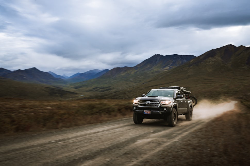
The Truck:
2017 Tacoma Double-Cab 6FT Bed
TRD Sport Upgrade
80,080km
Growing up, my family had a Toyota Sienna and we drove that van down to California, through the Rockies and across the Prairies more times than I can count. A decade later and I was doing those same trips in my 2010 4Runner – driving it to Alaska, along the Coast to California and across most of Canada and the United States. This year, I decided to switch it up and try a pickup truck. I was looking at both the Tacoma and Tundra – but decided that the Tacoma is the perfect truck for my adventures. It fits all my gear, has a narrower wheelbase and the V6 works great for all of my current needs.
On these early trips with my family I found a love for taking pictures… pointing my camera at whichever landscape we drove through. For this trip I had a Toyota Genuine Dash Camera installed so I could document the most scenic stretches of road while focusing on driving. With its wide angle lens I never missed those spur of the moment wildlife encounters on the road.

The Route:
Alaska-Canada Highway
Our trip started off on none other than the world famous Alaska-Canada Highway. Built in 1942 during the Second World War – this stretch of road runs from Dawson Creek, BC to Delta Junction, AK via the Yukon Territories. We spent a few days driving this road and took this opportunity to be on the lookout for Bears, Fox & Bison – this highway is an endless “wildlife tour”.


Top of the World Highway
On a search for clear skies and warmer weather – we continued North to the Top of the World Highway. A 127 km-long highway that connects Dawson City, YT to Jack Wade, AK. To access the highway you need to hop on a small ferry to cross the Yukon River just West of Dawson City. Once on the other side, you begin climbing up out of the valley where the road meanders through a series of ridge tops and stays well above tree line for more than 50km.


The Dempster Highway
Canada’s most Northerly Highway – starting just East of Dawson City, YT and ending well above the Arctic Circle in Tuktoyaktuk, NWT. The highway is named after Yukon Mountie William Dempster, who earned distinction for discovering the fate of The Lost Patrol in the early 1900’s. Due to physical distancing measures – we weren’t able to complete the entirety of the road but it was one of the highlights of the trip nonetheless. Just one more reason for us to come back and complete this route another year.


Haines Junction
This is a town I find myself coming back to time and time again. We left it till the end because I knew it would be hard to leave. This small community sits on the edge of Kluane National Park & Reserve – which is home to Canada’s tallest mountains and holds one of the largest non polar ice field systems in the world. While in Haines Junction – we hiked the King’s Throne Trail, drove up Haines Pass, stayed in a Yurt at the Mount Logan Lodge & flew over the Kluane Range in a small bush plane.


Whitehorse & Carcross
A key part of our trip was to ride our bikes – after looking through the series of trail networks in the Yukon it became apparent that the majority of the riding was in Whitehorse and Carcross. These towns also offered to be a great place for a resupply on gas, food & other essentials.


The Stewart-Cassiar Highway
Also known as Highway-37 – it is British Columbia’s most Northerly Highway and offered some of the best wildlife viewing we had on the entire trip. From Moose to Bears and Lynx to Buffalo – this road had it all. We took three days to drive this 874km stretch of road and made sure to take some time to turn off onto the Glacier Highway into Stewart, BC. Driving in we had little to no expectations but this road was one of our favourites. The valley is filled with giant old growth, waterfalls and glaciers running straight down to the highway. On top of that – the small town of Stewart has a handful of amazing cafés and restaurants to stop in at.

The Yukon was far more than we could’ve hoped for. We really did luck out with quieter roads than normal and some incredible stretches of clear weather. One of my favourite parts of the Yukon is the fact that there is something for everyone. Whether you’re looking for remote adventure or want to sightsee with your family – the Yukon has it all.
Eager to explore the Yukon for yourself? Head on over to TravelYukon.com
We want to acknowledge and thank the past, present, and future generations of all Native Nations and Indigenous Peoples whose ancestral lands we travel, explore, and play on. Always practice Leave No Trace ethics on your adventures and follow local regulations. Please explore responsibly!
Do you love the outdoors?
Yep, us too. That's why we send you the best local adventures, stories, and expert advice, right to your inbox.


