
Switzer Falls
Los Angeles County, California
Details
Distance
3.66 miles
Elevation Gain
728 ft
Route Type
Out-and-Back
Description
Added by Outbound
3.7-mile hike to 50-foot Switzer Falls in Angeles National Forest. Gabrielino Trail follows scenic creek, passes historic ruins. Best after rain.
Switzer Falls via Gabrielino Trail: LA's Most Scenic Waterfall Hike
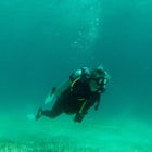
Switzer Falls is one of the most scenic waterfalls near Los Angeles. This 3.6-mile out-and-back hike on the Gabrielino Trail follows Arroyo Seco through shaded canyon, passes historic resort ruins, and rewards hikers with a stunning 50-foot cascade dropping into a pristine swimming pool. This trail is best done after recent rain for more water in the falls.
Located just off Angeles Crest Highway in Angeles National Forest, Switzer Falls combines natural beauty with fascinating history—you'll hike through remnants of early 1900s mountain resorts while following one of the loveliest stream corridors in the San Gabriel Mountains.
Trail Stats:
- Difficulty: Moderate
- Time: 1.5-2 hours
- Best For: Waterfall viewing, swimming, historic sites, creek hiking
- Season: Year-round (best winter/spring after rain)
- Dogs: Allowed on leash
- Parking: Adventure Pass required
Getting to Gabrielino Trailhead (Switzer Picnic Area)
Location: Switzer Picnic Area, Angeles Crest Highway (CA-2), Angeles National Forest
From Los Angeles/Pasadena: Take I-210 to exit toward Angeles Crest Highway in La Cañada Flintridge. Head north on CA-2 (Angeles Crest Highway) for approximately 10 miles. Look for the Switzer Picnic Area sign on your right. Drive down the access road to the lower parking lot.
Parking: There is a parking lot just next to the trailhead at Switzer Picnic Area. If you go on the weekend and run into a crowd, there's overflow parking in upper lots near the highway, adding a little distance and elevation to your trek. Arrive early on weekends to secure lower lot parking.
Adventure Pass Required: An Adventure Pass must be displayed in vehicles when using the Forest for recreation. Purchase at Clear Creek Ranger Station (about 0.5 miles before Switzer turnoff) or online at fs.usda.gov. One pass per vehicle required.
Important: Gates typically close around 5-6 PM. Once inside you can always get out, but plan accordingly.
Trail Description: Gabrielino Trail to Switzer Falls
Trailhead (Mile 0): Once you've walked through the Switzer Picnic Area, find the trailhead near the bathrooms at the beginning of the lower parking lot. Cross the bridge over Arroyo Seco and follow trail signs into a beautiful shaded area with additional picnic benches.
Arroyo Seco Descent (Mile 0-1): The trail begins on old pavement from the 1930s—now mostly overgrown—descending gently through shade alongside babbling Arroyo Seco. The stream is lined with oaks and alders, with water cascading over granite into mirror-like pools. You'll make a few easy stream crossings where there are multiple options to rock-hop—deft footing and a walking stick can keep your feet dry, though you might want to pack extra shoes and socks just in case.
This is a relatively easy hike into one of the loveliest sections of the San Gabriel Mountains. The trail meanders back and across the stream running down the spectacular Arroyo Seco Canyon. In summer, wild blackberries grow along this section.
Switzer's Camp Ruins (Mile 1.1): About a mile into the hike, the trail will fork at a stream crossing. Both routes rejoin shortly. The left trail takes you through ruins of Switzer's Camp (part of Switzer-Land resort from the early 1900s). There's not a whole lot left, and you wouldn't even know you were walking through ruins unless you read about it ahead of time. You can walk up to where a small chapel once stood overlooking a waterfall—the Forest Service demolished it for safety, but some arched foundations remain scattered along the ridge.
Exposed Ridge Climb (Mile 1.1-1.7): After the ruins junction, the trail leaves the creek and climbs out of the canyon's shade onto an exposed section with scrub vegetation. As you continue climbing, you'll come into close contact with Arroyo Seco, so be careful if there have been big flood warnings. If the sun's beating down you'll definitely feel it here—grab the sunscreen. But you'll also get great vistas of the surrounding mountains, which can go completely unnoticed when you're by the riverside. The trail is pretty narrow here, so it's hard to stop and get amazing photos.
Descent to Falls Junction (Mile 1.7): At the 1.7 mile mark, the trail switchbacks from the ridge down onto the floor of Bear Canyon. You'll come across a trail junction where Bear Canyon Trail heads downhill. Stay to the left for Switzer Falls—it's just 0.1 mile away.
Lower Switzer Falls (Mile 1.8): From the junction, follow signs pointing toward the falls. You'll head upstream on Arroyo Seco with multiple stream crossings—keep heading upstream. The 25-foot lower Switzer Falls appears ahead, dropping into a beautiful pool that's 3-4 feet deep. There's a narrow trail that will take you to the base of the falls, but you'll see signs to proceed at your own risk. Be careful if you're going down. If you do make it down to the base, you may want to grab a quick swim in the pool below.
Upper Switzer Falls (Optional, +0.5 miles): For the more adventurous, Upper Switzer Falls—the taller 50-foot main cascade—is a short trip upstream. The route goes up along granite on small single track, then across slippery cuts in stone. I would not recommend doing this if it's wet as you're likely to slip. Once past the lower falls, follow the creek upstream (no formal trail) while watching for poison oak. After a quarter to half mile, you'll reach the impressive 50-foot Upper Switzer Falls. There's no swimming hole here, but the views are spectacular.
Bear Canyon Extension (Optional, +2 miles): If you want to extend your hike and find some swimming holes away from crowds, take the right turn at mile 1.7 instead of heading to the falls. Continue down Bear Canyon Trail for about 0.5-1 mile. At the 2-mile mark from trailhead, there's a deep, multilayered pool that's a great swimming hole. There was at one point a rope swing hanging over the pool. If this pool's occupied, there's another smaller one about 5 minutes further down the canyon.
Return Journey: Retrace your steps back to the trailhead. The trail is mostly uphill on the return—you descended 685 feet coming in. The gradients are forgiving and gradual, making the climb out manageable.
Seasonal Waterfall Flow
CRITICAL: Switzer Falls is best after recent rainfall. Winter and spring typically provide the most reliable flow, while summer and fall can see reduced water or even dry conditions during drought years.
Best Flow: 1-3 days after heavy rain, especially in winter/spring when snowmelt adds to the flow.
Moderate Flow: Early spring, late winter during normal rainfall years.
Low/No Flow: Late summer, fall, and during drought years the falls can be disappointing or completely dry.
What to Bring
- Supportive trail shoes or hiking boots (rocky trail, stream crossings)
- Extra shoes/socks (in case feet get wet)
- Water (2+ liters on warm days)
- Sunscreen (exposed ridge section)
- Hat and sunglasses
- Bathing suit (swimming in pools)
- Towel
- Camera
- Trekking poles (helpful for stream crossings)
- First aid kit
- Snacks or lunch
After Your Hike
If you didn't bring lunch, head into La Cañada Flintridge and reward yourself for the day's hard work at La Cabanita Mexican Restaurant—a local favorite for post-hike meals.
Nearby San Gabriel Mountains Hikes
Eaton Canyon Falls: Easier waterfall hike with large gathering area at base—good for families with children. Check for closures due to 2025 the Eaton Fire (USFS).
Echo Mountain via Sam Merrill Trail: Historic ruins and views from old Mount Lowe Railway.
Mount Wilson Trail: Challenging climb to Mount Wilson Observatory.
Gabrielino Trail (Extended): This trail continues for many miles through Angeles National Forest, connecting various trailheads from Chantry Flat to Altadena.
Mental Health & Wellness Benefits
Switzer Falls offers mental health benefits through creek-side forest immersion, the meditative sound of flowing water, and the unique combination of natural beauty with human history creating deeper connection to place.
Water Therapy Along Arroyo Seco: The entire hike follows a babbling creek with water cascading over granite into mirror-like pools. The constant sound of flowing water provides natural white noise that masks intrusive thoughts, lowers cortisol levels, and promotes meditative states. Multiple stream crossings require present-moment attention, grounding you in physical experience rather than mental rumination.
Shaded Forest Sanctuary: The oak and alder-lined canyon provides cool respite and classic forest bathing benefits—reduced stress hormones, lowered blood pressure, improved immune function through phytoncides. The shade makes this comfortable even on warm days, removing weather as a barrier to outdoor wellness.
Historical Connection & Perspective: Walking through Switzer's Camp ruins connects you to early 1900s wilderness enthusiasts who sought the same mountain escape you're seeking today. This historical continuity provides perspective—your stress is temporary, nature and human need for it are timeless. The demolished chapel site reminds us that structures are temporary but wild places endure.
Swimming & Cold Water Therapy: The pools at the base of lower Switzer Falls provide hydrotherapy and cold water immersion benefits. Post-hike swimming releases endorphins, cools the body, provides sensory reset, and creates reward feeling that reinforces outdoor activity habits.
Moderate Challenge & Accomplishment: The exposed ridge section provides brief challenge that builds confidence without being overwhelming. The mostly downhill journey to the falls makes the destination feel achievable, while the uphill return provides satisfying workout that releases mood-boosting endorphins.
WELLNESS TIP: Visit Switzer Falls on a weekday morning 2-3 days after winter rain when the waterfall roars but crowds are minimal. Hike slowly down the Gabrielino Trail, pausing at each stream crossing to listen to the water. At lower Switzer Falls, sit on the rocks for 15 minutes just listening to the cascade. If you're comfortable, take a brief dip in the pool—the cold water shock followed by your body warming creates powerful mood lift. The combination of forest immersion, water sounds, physical movement, and optional cold plunge provides complete stress relief lasting days beyond the hike.
Why Choose Switzer Falls via Gabrielino Trail?
If you're seeking LA's most scenic waterfall hike combining natural beauty, fascinating history, and accessible challenge, Switzer Falls via Gabrielino Trail delivers one of the San Gabriel Mountains' best experiences. This moderately challenging route offers a 50-foot waterfall with swimming pool, shaded creek-side hiking along Arroyo Seco, historic Switzer's Camp ruins, multiple stream crossings, optional Bear Canyon swimming holes, relatively easy access from LA/Pasadena, extension options for longer adventures, and year-round hiking (best after rain).
Whether you're an LA resident seeking weekend waterfall escape, a history buff interested in early mountain resorts, a swimmer wanting natural pools, a photographer chasing flowing water, or anyone needing accessible San Gabriel wilderness, Switzer Falls provides rewarding adventure just 10 miles up Angeles Crest Highway.
The Gabrielino Trail's excellent shade, gentle gradients (going in), and beautiful Arroyo Seco make this one of the most pleasant waterfall hikes in the region. The exposed ridge section adds just enough challenge to feel earned without being extreme.
Make sure you have your Adventure Pass for parking, check recent trip reports for waterfall flow, pack extra shoes for stream crossings, bring your bathing suit for swimming, and get outside to discover why Switzer Falls remains one of the most popular waterfall hikes in all of Southern California. The combination of rushing water, towering trees, granite pools, and mountain vistas creates moments of beauty available nowhere else so close to LA.
Download Outbound mobile app
Find adventures and camping on the go, share photos, use GPX tracks, and download maps for offline use.
Get the appFeatures
Switzer Falls Reviews

The water levels have been pretty low. I usually go early in the morning, and catch the sun at noon on the way back down. The cool air feels great on hot summer days.
2.5
If you are steady on your feet and adventurous it's worth the hike up past the 15' falls to the larger 50' falls base!
4.5
Unfortunately right now there isn't nearly as much water as in this photo due to the drought, but still a great place to explore, especially after the next rain.
5.0
Leave No Trace
Always practice Leave No Trace ethics on your adventures and follow local regulations. Please explore responsibly!
Nearby

Bear Canyon via Switzer Falls Trailhead

Gabrieleno Trail: Switzer Falls to Hahamonga Watershed

Mt. Disappointment via Billy Riley Trail

Teepee Trail

Millard Falls

Idlehour Trail
Discover
Community
Mobile Apps

© 2026 The Outbound Collective - Terms of Use - Privacy Policy