Pocket Picnic Shelter
Book this listing through our partner Recreation Gov
About Pocket Picnic Shelter
Overview
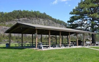
Pocket Picnic Shelter is a popular location for large groups that want to enjoy a secluded area. The densely forested area was a Civilian Conservation Corps camp from 1938 to 1942. Some remains of the old camp are still visible in the area.Recreation
Visitors enjoy the 3.5-mile Pocket Foot Trail that loops between the picnic area and a nearby campground. Interpretive signs are placed along the route, including a brief description of the area. It is a relatively wide path and a nice, easy walk.Facilities
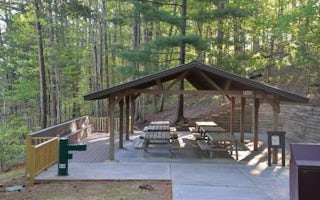
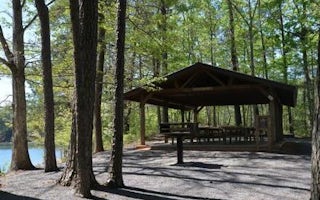
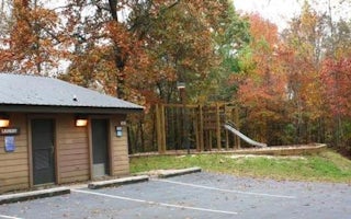
The accessible picnic shelter is available for group use with a reservation. If the area is not reserved, it is available on a first-come, first-served basis. The facility can accommodate up to 75 people and 20 vehicles.The site is equipped with tables and grills. Accessible vault toilets are also provided. Drinking water is available across the parking area, in the main picnic area.
Natural Features
The picnic shelter is located off the Ridge and Valley Scenic Byway. The area is named for its unique geology formed when water-soluble limestone was eroded over time, dropping the ground level. The surrounding ridges, which contain iron ore are filled with pockets.Nearby Attractions
The closest town is Dalton, Georgia, which is about 25 miles east of the picnic area. Dalton has numerous grocery stores, restaurants and gas stations available.Pocket Picnic Shelter Reviews
Have you stayed here? Be the first to leave a review!
Top Spots in or near Armuchee
Hike to Keown Falls
LaFayette, Georgia
1.8 mi
/ 450 ft gain
Keown Falls Trail is a moderate loop perfect for a Spring day (especially after those April showers). The trailhead is located in the Keown Falls picnic area which is very spacious spotted with several picnic tables. This would be a great place for a family gathering and is spacious enough that the next family would not be within earshot. The trail starts out as a fairly flat trek through fal...
Hike the Marble Mine Trail
Summerville, Georgia
4.3
1.7 mi
/ 200 ft gain
This 1.7 mile loop is almost entirely on a wide pebbled road making this hike perfect for getting families and friends outdoors. Though there is some elevation gain, the Marble Mine Loop is quite an easy walk. Go during the Fall and the trees are boasting all the reds, oranges, and yellows of the season. About halfway through (circa .85 mi), the trail meets an old abandoned mine site with acce...
Hike the West Overlook Trail and CCC Stone Tower Trail Loop
Chatsworth, Georgia
4.7
1 mi
/ 200 ft gain
Fort Mountain State Park is filled with horse trails, biking trails, walking trails, camping sites, and a lake. Once you arrive at the park you pay a $5 entrance fee and will receive a park map. While visiting I walked the West Overlook Trail and came back down the CCC Tower Trail. This is a 1 mile trail great for anyone of all ages. You start off at 2,650 ft. of elevation and gain 200 ft. of e...
Hike the Gahuti Trail
Chatsworth, Georgia
4.0
8.1 mi
/ 1223 ft gain
Fort Mountain rises prominently from the plateau to the West, serving as the start of the Blue Ridge Mountain range in Georgia. The Gahuti Backcountry Trail circumnavigates the mountain, with several overlooks with views in all directions. At 8.1 miles, this hike is moderately difficult, but can be done by most in a half-day.
The Gahuti Trailhead is at the parking lot for the Cool Springs Ov...
Hike the Tumbling Waters Trail
Ellijay, Georgia
5.0
1.3 mi
/ 160 ft gain
Just North of Carters Lake lies one of its tributaries, Tails Creek. The Tumbling Waters Trail follows along a scenic stretch of this creek as it cascades its way towards the lake. This trail is moderately trafficked and considered a local favorite.
The Tumbling Waters trailhead also contains a boat ramp for recreational use. A daily fee of $3 is required to use these facilities and the mone...
Camp at Cloudland Canyon State Park
Rising Fawn, Georgia
4.8
If you're looking to camp somewhere with exceptional hiking and beautiful waterfalls, Southeastern Tennessee locals know not to look further than Lookout Mountain. Located on the western edge, Cloudland Canyon State Park straddles Sitton Gulch Creek and is perfect for a weekend exploration.If staying a night or two, your accommodation options are (almost) endless. From cottages and yurts to RV ...
Camping and Lodging in Armuchee

Chatsworth, Georgia
Rereg Dam Day Use Area Shelter
Overview
Reregulation Dam Day Use Area is actually two day use areas situated on the North and South Sides of the Coosawattee River. Bot...

Chatsworth, Georgia
Northbank Day Use Area Shelter
Overview
Northbank Day Use Area is located in the North Georgia Mountains about 70 miles north of Atlanta on Carters Lake. The sparkling ...

Ellijay, Georgia
Damsite Day Use Area Shelter
Overview
Damsite Day Use Area is located on Carters Lake in the North Georgia Mountains about 70 miles north of Atlanta. The sparkling w...

Ellijay, Georgia
Woodring Day Use Area Shelter
Overview
Woodring Day Use Area is located in the North Georgia Mountains about 70 miles north of Atlanta on Carters Lake. The sparkling ...

Ellijay, Georgia
Doll Mt. Campground
Overview
Doll Mountain Campground is located in the North Georgia Mountains on beautiful Carters Lake, Which is just a short 70 miles ...

Ellijay, Georgia
Doll Mountain Day Use Area Shelter
Overview
Doll Mountain Day Use Shelter is located in the North Georgia Mountains about 70 miles north of Atlanta on Carters Lake. The sp...
Unfortunately, we don't have up-to date pricing data for this listing, but you can check pricing through Recreation Gov.
Book NowAdd your business today to reach The Outbound's audience of adventurous travelers.
Community
© 2024 The Outbound Collective - Terms of Use - Privacy Policy


