Big Hikes in Montenegro: Durmitor National Park
The Republic of Montenegro is one of six countries that made up the former Yugoslavia. It’s rugged and covered with mountainous terrain. Not so long ago, I had the opportunity to visit Durmitor National Park, situated in the Northwestern part of the country. The goal was to hike and climb Bobotov Kuk, the highest peak at 2553 meters, in the massif that is Durmitor itself.

Getting to Durmitor involved a lot of winding backroads driving, starting out in Podgorica and eventually making my way to Žabljak. Podgorica is the capital city of Montenegro and has an international airport if you would prefer to fly direct, but I first arrived there from Serbia, after a long train ride from Belgrade. I love train rides. Such a civilized way to travel.
Žabljak is the hub for all things in the area. It is an outdoor mecca, with excellent hiking and swimming opportunities in the warmer months, and more than a hundred days of snow cover in the winter for skiing and winter sports. If you’re into rafting, you should definitely check out Tara Canyon, the second deepest canyon in the world. The water has an amazing green colour to it, unlike anything I have seen elsewhere.
 Tara Canyon
The Hike to Bobotov Kuk
Originally, I was going to go hiking by myself, but was fortunate enough to make friends with a nice fellow named Oleg. He and I agreed that Bobotov Kuk seemed like a reasonable goal, and off we went.
The day started out spectacularly well. Low lying cloud and fog made for fantastic photos, and by mid morning the sun had burned through the cloud and we had sunshine for nearly the entire day. Except near the top, but more on that later.
 Shooting in diffuse light - Awesome.
I was seriously loving the light that day. I probably made Oleg hike towards me at least two dozen times, or else I would race ahead of him to get some awesome backlight action.
 I had him do this approach many times. He's still smiling in this one.
 Fog partially obscures our path up and around the first part of the hike
The terrain in Durmitor National Park is quite dry, and very rocky. You’ll need sturdy footwear if you want to hike comfortably. There is a lot of scree and tall grass on the lower parts of the park, but the signage is quite good. You'll be fine!
The clouds did eventually start to roll in over the course of the day, and as time went on I was feeling certain that we were going to have a soggy summit. As we ascended, we passed other cool features that my friend Oleg pointed out to me. One of my favourite things was a set of jagged peaks known as ‘Zupci’, which means ‘teeth’ in Bosnian. The name is quite apt.

To the Top
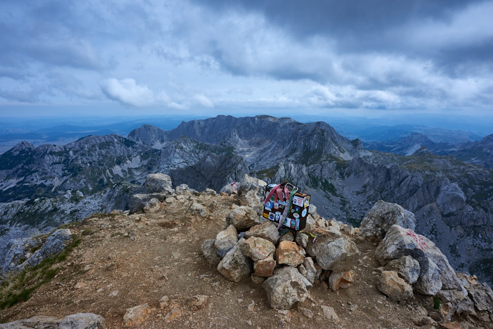
As luck would have it, the rain held off and we made it to the summit under fairly heavy cloud cover, but no rain. We were both smiling all around — we had just climbed the tallest peak in the Dinaric Alps. A pretty solid day in my books. We didn’t stay up there for too long, because the sun was beginning to set and that would have meant running out of daylight on the way down. There is a geocache box right at the top, for those who are into that sort of thing. I signed the log book and left a few stickers.
 The Geocache box on the summit
 Yeah baby.
Did I take a selfie? You bet I did! And remember, when ever you find yourself in a situation like this, the important part is to remember what time it is. Adventure time!
Till next time!
We want to acknowledge and thank the past, present, and future generations of all Native Nations and Indigenous Peoples whose ancestral lands we travel, explore, and play on. Always practice Leave No Trace ethics on your adventures and follow local regulations. Please explore responsibly!
Do you love the outdoors?
Yep, us too. That's why we send you the best local adventures, stories, and expert advice, right to your inbox.


