
Hike Bear Peak
Boulder, Colorado
Details
Distance
7 miles
Elevation Gain
2810 ft
Route Type
Out-and-Back
Description
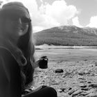
Added by Kathleen Morton
This hike dog-friendly hike is not just a great workout, but will reward you with breathtaking panorama of Boulder and distant view of Denver.
The best advice I can give you? Wake up early to start this hike.
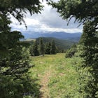
Even though the Bear Peak hike will only take you about 4-5 hours round trip, it will still be advantageous to get off the mountain before afternoon and evening storms might pass through. This is a steep 7-mile out and back trail.
Start at the South Mesa Trailhead. Take Eldorado Springs Drive until there's a dirt road turnoff; take this down from the road to the parking lot.
After your gear is loaded, prepare for a steep climb that will most likely leave you breathless. The trail is easy to follow, but it is strenuous, as you're climbing 2,810 ft. in elevation (a total of 3,000 ft. elevation gain roundtrip).
Prepare for snow on your hike. In the spring or fall, areas of this trail may become wet, but you should still be warm in the Colorado sunshine. Most of this hike is forested, and will offer shade in the early morning.
This is a narrow trail. Watch for other hikers, and if you're bringing a four-legged friend, make sure to keep them close.
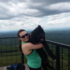
It will take you about 2 hours to reach the top, where you might want to hang out and eat some trail snacks. As it gets later in the day, the peak gets quite crowded. Enjoy panorama views of Boulder and look out in the distance to see Denver and surrounding cities.
From the top, head back down the way you came. This trail also connects to the Towhee Trail, Homestead Trail, South Boulder Creek Trail and Big Bluestem Trail.
If you're lucky, you may see some wildlife on your hike, including falcons, hawks, songbirds and mule deer.
After I finished this hike, I relaxed the rest of the day. It's exhausting hiking more than 2,800 feet elevation in one day!
Download Outbound mobile app
Find adventures and camping on the go, share photos, use GPX tracks, and download maps for offline use.
Get the appFeatures
Hike Bear Peak Reviews

This was a great hike, but the description given here isn’t helpful. Follow the main trail (called Mesa I think) until you hit the Shadow Canyon trail on the left. Shadow Canyon will take you up! If you stay on the main trail you’ll wind around back to Shadow Canyon but there are a lot of other offshoots and it’s not clear, I don’t recommend it. South Boulder Peak is to the left when you get to the saddle (Bear Peak to the right) and it’s also beautiful!
4.0
This is a great hike, but the directions on getting there in this article can be a little deceiving. You will take Eldorado Springs Drive, but the road eventually turns into a dirt road if you go too far. You will actually be looking for trail head signs on your left or right for the City of Boulder OSMP, it is just a little ways around the curve after the Rocky Mountain Fire Station. The North side is South Mesa and the South side is Doudy Draw Trailhead. DO NOT park in the road, it is illegal and the chances of you getting a ticket are extremely high. Be conscious of signage as well, almost all of South Mesa is closed during the week right now due to restoration work. Also, these trailheads are extremely busy on the weekends, especially in the summer. This leads into my next point, THIS IS NOT YOUR ONLY OPTION TO BEAR PEAK!!! There are several other stunning options. You can hike in through Shanahan Ridge, Cragmoor, Bear Mountain Road, NCAR, or even from Green Mountain West ridge if you are feeling really adventurous! Plan your trip accordingly and make sure you "Know Before You Go!"
5.0
This is a great hike! But... it is long and strenuous. Although you will see lots of trail runners coming up and down, I thought this hike was an ass kicker. I brought my parents who are approaching 60 on this hike and we were able to complete it in about 7 hours round trip which included a lunch at the peak. By the end of the hike we were spent, I recommend a lot of water and a very early start as this trail was packed with people.
5.0

Hiked this trail on 3/24/17. Was a beautiful day and a challenging hike. The toughest part of the day was finding my way to the top. Because of the floods a few years ago, many of the trails are closed, requiring you to take alternate routes to the top. The last 1/3 of the hike really ramps up the difficulty, but it definitely worth the extra effort for the views near the top. Highly recommended.
4.0

Definitely do it when there is no snow unless you want a bit of a challenge. At the top it's gorgeous and you can see all of boulder.
5.0
This hike is definitely advanced! But, if you are up for a little work out, you will get some amazing views of Boulder and the front range.
5.0
Leave No Trace
Always practice Leave No Trace ethics on your adventures and follow local regulations. Please explore responsibly!
Nearby

Hike the Big Bluestem Trail Loop

Hike South Boulder Peak

Doudy Draw Trail

Hike the Eldorado Canyon Trail

Hike the Flatirons Vista Loop Trail

Hike the Rattlesnake Gulch Trail
Discover
Community
Mobile Apps

© 2026 The Outbound Collective - Terms of Use - Privacy Policy