
Discover Your Next Adventure with Topographic Maps
Not every good viewpoint already has a trail report written on it.
Getting Started
It has become pretty much standard for me to search for my hiking and photography destinations by wandering aimlessly through my favorite free topographic maps website, looking for geographic features that strike my interest. Why would I do that when there are plenty of isolated, seldom-visited locations with existing beta, you ask? Because sometimes I just want to feel like Lewis and Clark, dammit! (To be fair, this tactic doesn't actually lead me to a completely unexplored territory, because this is 2017 and those don't exist in Washington anymore.) A map-guided expedition almost always ends with a good story to tell, but rarely goes according to plan, so it is essential to be prepared for anything. Ok, so back to the maps...
When I open up a topo map looking for a destination, I usually have a general location in mind, but my curiosity gets the best of me until I pan elsewhere looking for unique geography. These features include deep valleys, proximity to lakes, snaking river canyons, steep rock walls, areas that could create nice shadows around dusk/dawn, or just general high elevation points. (I like summits, OK?) After settling on a location, I scour the internet for any existing beta, check Google Earth and a fine Android app called Sun Surveyor if I want to catch the sunrise or sunset (or the photographer's ephemeris), then measure out the hiking distance on CalTopo, pack my bags and go!
Story Time!
When I was planning a weekend into the mountains this past summer, I opened a map looking at the area west of Lake Chelan near Spider Meadows. As it turned out, there was a forest fire there and the entire section of trail was closed for the year. Bummer. But no worries, because I quickly started to wonder what was to the east of Lake Chelan - I'd never heard anyone talk about that area. As I started to scroll over, I began to notice a few Bulger Listers looking all high and mighty - always a good option when I have the time. The next step was to look for any beta - Summitpost had what I was after, but the pictures weren't appeasing the part of me that wanted an epic view. I went back to the topo map and came across Lake Chelan itself. It looked like there were plenty of peaks close to the shoreline and a lot of them had ridges that sloped down towards the lake. Yahtzee! This was what I was looking for - the ridge was low-angle sloping so I had confidence that it was traversable.

Next I opened up Google Earth to make sure I wasn't running into something unforeseen and to find the ridge with the best view. I came across Ferry Peak and its long finger ridge. The end of the ridge would have sweeping 180 degree panoramic views of Lake Chelan if Google Earth was correct, and the ridge looked relatively barren of trees (or so I thought...). Right about now, I'm starting to believe that this is going to be a great trip

After getting beta on Ferry Peak (because I had to summit something, right?) the final step was to measure out expected hiking distance using the built-in features on CalTopo. Ooof 15 miles and about 6000' cumulative elevation gain round trip... this is doable, but it's going to be rough.

The weekend came and I left my perch in Seattle long before sunrise so I could absolutely, 100%, positively be done with this hike before sundown. It was unfamiliar terrain, after all... The drive along Lake Chelan is incredibly scenic and I highly recommend it if you're a white knuckle driver like me. Anyways, I got to the trail head and the first ~3.5 miles were easygoing. Then the bushwacking began. Nothing too harsh and definitely passable. Around 4.5 miles in, I started scrambling to the summit - and I kept scrambling with three points of contact for seemingly forever. Turns out it was 0.6 miles of scrambling which is way more than I'm used to. This was setback #1. The summit views, as expected, were less than spectacular. But I'm thinking, "hey at least the ridge will be easy."
WRONG.
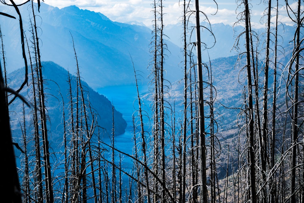
I quickly discovered that the backside of Ferry Peak had been ravaged by the 2001 Rex Creek Complex forest fire. (This is another feature you can check in CalTopo using map overlays. I know what you're thinking, and the answer is: nothing. There is nothing that CalTopo cannot do.) Trees were down in every which direction and hiking through them was more difficult than crabwalking a 10k on a beach while wearing ankle weights. This was setback #2.
Now a smart person would turn back and accept their defeat, but I'm stubborn and there were views to be had, so I journeyed onward. I was so focused on where my feet were going to go each step that I completely lost track of time - when I arrived at my final destination, it was already almost 4pm and there were about 4 hours until sundown... No bueno.
BUT THAT VIEW! ... was not as spectacular as expected. Singed trees were still standing everywhere and smoke from that Buck Creek wildfire that blocked my initial plans was putting a haze over everything.

Ok now I'm starting to get a little aggravated and worried about the trip back. Is there a quicker way to bypass all these downed trees? Do I go back up Ferry Peak and hope that I make it down while there's still light or do I go around to a mountain pass that used to be a trail many, many years ago? This is where some intuition and map-reading skills come in handy.

Nature made the decision for me: the sun was setting and I wasn't even back at Ferry Peak. I would have to go the long way - still risky because I wasn't entirely sure of what lay ahead, but less so than down-climbing in the dark or staying put and enduring the cold night. It turned out to be a difficult route to follow, but fairly quick moving in comparison to earlier. It wasn't long until it was pitch black and my headlamp needed to make an appearance. A few hours later, it was about 11 pm and I decided to look up instead of staring at the illuminated ground and my jaw absolutely dropped. Hot damn! These are the moments that make it all worth it.


After 18.2 total miles and 5400' elevation gain, I eventually made it back to my car and drove home to Seattle... arriving at 8 am the next day, effectively saying sayonara to a normal sleep schedule for the week.
Final Musings
So what did I learn from this? And why am I telling the world about it? Well for starters, if you have that extra adventurous tick and want to blaze your own trail, it is extremely important that you are prepared physically and mentally for all weather conditions, hazards, obstacles, and potential setbacks. You never know exactly what you are going to encounter. First aid is a must and telling a friend where you will be should be a high priority. If I had gotten hurt out there, nobody was going to find me for a very long time. This preparation should also include awareness of the terrain you are entering, including if you are entering a fragile vegetation area. Following LNT principles, I would not have continued onto the ridge if the forest fire had been more recent. This is especially important if you are traveling in large groups, because you will have a far more potent impact on the forest's recovery. Just some things to keep in mind as you plan your next adventure. Good luck out there!
We want to acknowledge and thank the past, present, and future generations of all Native Nations and Indigenous Peoples whose ancestral lands we travel, explore, and play on. Always practice Leave No Trace ethics on your adventures and follow local regulations. Please explore responsibly!
Do you love the outdoors?
Yep, us too. That's why we send you the best local adventures, stories, and expert advice, right to your inbox.


