
To the Top of Britain and Back
Sometimes pictures can describe what words can't.
It was December in the Scottish Highlands, which means it was pitch black and chilly when my friend Parker and I began our hike up to Britain’s highest peak Ben Nevis at about 7:30 in the morning. Normally that would also mean grey and rainy, but we had captured a break in the weather that gave us three days that were bone dry with clear skies.
Staying at the Glen Nevis Youth Hostel, we stepped out right at the foot of the mountain whose dark mass loomed some 4,400 feet above us in the morning dusk. We had about a mile and a half diversion due to trail construction near the base. But before the first morning light was up above the surrounding ridges, we were on the steps of the mountain path that would take us to the summit.
Sometime back in the late 1800’s, a weather forecast station was built on the summit of Ben Nevis because of its vast view of the surrounding highlands. Most of the terrain up to the top is near vertical and icy (which is what has made it such a popular ice climbing location) or quite shallow and a long ascent. With a sudden need for a quick and easy way up, a designated mountain path was carved into the side of Nevis that circumnavigates a surrounding foothill before switchbacking its way up the southern face. A large amount of natural rock steps have since laid the ground work for a well-made stone staircase that led us up about two thirds of the hike.

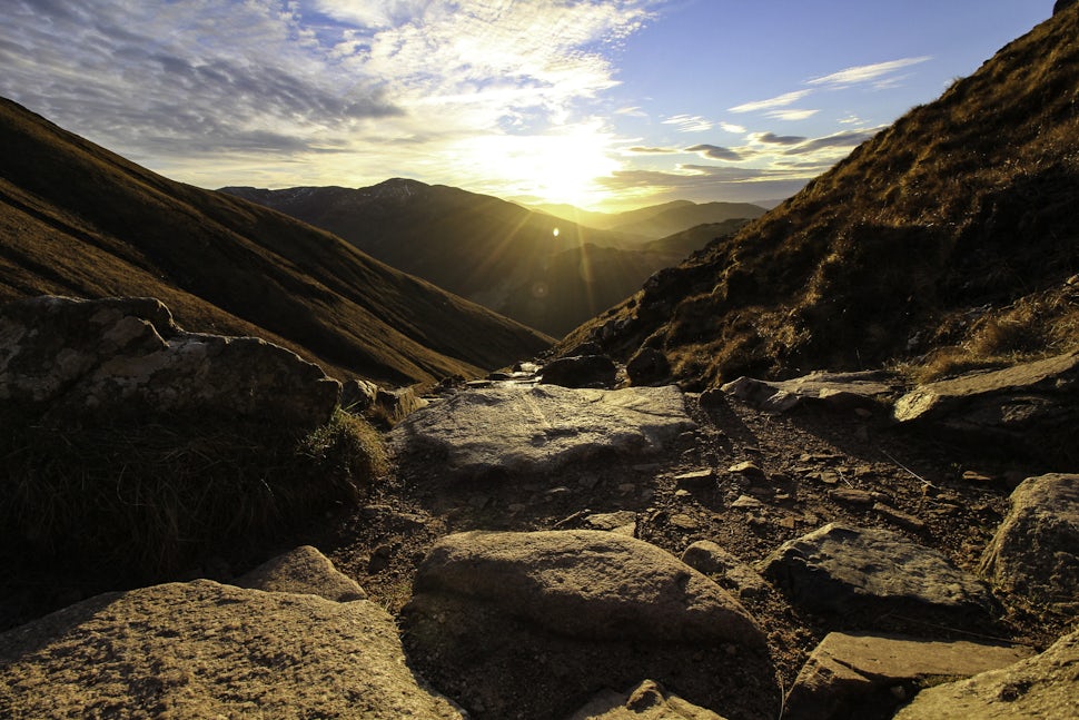
 There was a total change in color as soon as the sun broke over the valley ridge
Every time our view cleared another mountain ridge in the distance, we were convinced we had found the best view only to have the process repeated a few hundred feet higher. I felt like a kid in a candy shop with every direction I faced. I had no idea that Scotland was so rugged, so untouched. Timeless beauty resonated off the stony slopes as the dimmer-switch on the sunlight slowly increased throughout the morning.


We touched our hands to the summit stone marker about half an hour ahead of schedule, and we could not have timed it any better. With only about two hours left of daylight, the sun was still high enough to cut through the thin layer of clouds streaked across the sky like cotton balls that had been pulled and stretched apart. It sat there, seemingly suspended in space for the time we were up there, perfectly illuminating the sharp blue peaks.
 SUMMIT!!

The view is usually enough to validate the trek up any summit. But to be at the highest point in Great Britain and able to walk among the ruins of the old forecasting station made Ben Nevis truly remarkable. Except for one hut, the roofs are long gone off all the buildings. Walls, doorways, and window frames still stand though giving an eerie sense of what it must have once looked like.


 The cross is inscribed with the word "MUM", with "In loving memory" etched into the backside. The cross has been up there for years.

We headed back down the mountain with the sun. Just a few minutes walking down the trail we were treated to an incredible fly over by a low passing fighter jet. He couldn’t have been more than two or three hundred feet off the peak and did a slow, lazy roll as he followed the topography of the earth down into the valley. Our initial reaction to hearing a low, steadily building rumble on a steep, rock covered section of a mountain face was that the whole thing was about to come sliding down onto us. Too stunned to even try to capture a picture of the event, I just stood there and Parker took a seat on the snow after the jet's engines faded in the distance; both of us more than relieved to have just been buzzed by a plane rather than buried by rock. We took our time heading down enjoying the last rays of light in the valley and the beautiful day we had lucked out with.


Coming into the last mile of the trail, we were given front row tickets to trail maintenance being down by helicopter. Massive bundles of stone were being airlifted onto specific segments of the trail in order to reinforce the mountain slopes, rebuild the steps, and help prevent erosion. Standing right near the construction crew, we were close enough to be buffeted by the downdraft of the helicopter's rotors and see the pilot's deft maneuvers with the joystick as he brought the craft just feet away from rocky surface.


It was a smooth trek back down to the bottom, and we finished out the 13 mile round trip under a fiery pink and red sunset. On a day when you can take in their full scope, the Scottish Highlands truly are incredible to behold. They were described to me once as "prehistoric" and I don't think there could me a more accurate word. For thousands of years they have sat undeveloped and untouched, and I hope they may remain that way for thousands more to come.
Follow along for more of my outdoor wanderings at www.asiwandered.com, and on Instagram @as_i_wandered. Happy wandering!

We want to acknowledge and thank the past, present, and future generations of all Native Nations and Indigenous Peoples whose ancestral lands we travel, explore, and play on. Always practice Leave No Trace ethics on your adventures and follow local regulations. Please explore responsibly!
Do you love the outdoors?
Yep, us too. That's why we send you the best local adventures, stories, and expert advice, right to your inbox.


