
Every Backpacker Should Print Their Maps From Caltopo. Here's Why.
You may never go to the store to buy another map again.
When I started backpacking, I relied almost exclusively on Green Trails maps from REI. These were great quality maps, but every time I went on a new trip I had to purchase a new map which got old real fast. Luckily a co-worker of mine at Tarptent introduced me to Caltopo. If you haven’t heard of this website before, I cannot recommend it enough. For those who are already familiar, I hope this article will show you a few tips and tricks that you didn’t know existed before.
Without further ado, here are my top 8 reasons to use Caltopo's website.
1. It’s FREE (but if you can swing it, you should pay for a membership)
Yup you heard that right, free – just go to www.caltopo.com. It's pretty amazing to me that they offer all of these great tools without charging. With that said, there are paid memberships that are very affordable (just $20/year Basic and $50/year Pro) and come with benefits like higher resolution images, larger maps, and more. Even if you won't be using the added features, this is a fantastic product and if you can afford a membership, it will help off-set the cost of maintaining a resource that is incredibly valuable to the hiking and backpacking community.
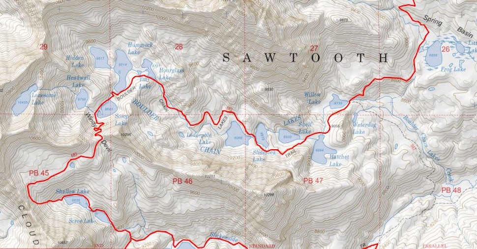
2. It lets you print the exact size and scale map you want
No more thumbing through the shelves at REI or your local equivalent for the map you need. Now you can export a PDF of any portion of the map you want at any scale. I like to take advantage of this feature by printing one large-scale, overview map of the trail, and then if necessary, one or two zoomed in maps that allow me to see critical terrain in more detail. If you’re the thru-hiking type, it’s also possible to export multiple PDFs at the same zoom and then tape them all together to make one enormous, folding map (if you have Photoshop or similar software, merging is even easier since you can do it digitally).
3. You can toggle between and/or stack different map layers
Using the menu in the upper right, you can quickly switch between a whole host of maps including US Forest Service, USGS, historic maps, cycling maps, and Google satellite, terrain, and street maps. This is great for pre-trip research where you want a map you’re familiar with (like Google) to locate the general area and/or plan your drive. Then once you’re ready to look at trail details and elevation lines, just switch to one of the topo layers. No more need to have loads of internet tabs open, Caltopo combines everything in one place.
Once you start jumping between layers, you’ll notice you can also stack two or three on top of each other at custom opacities. One of my favorite tricks is overlaying 20-30% opacity Normal Relief on top of US Forest Service. This retains all the trail information while the relief helps highlight elevation features so you don’t have to rely solely on comparing contour lines. And better yet, you can print stacked layers just as you would a normal PDF (described above in #2).
4. It calculates elevation, mileage, and terrain statistics for YOUR route
While most trails have a guide book with this information already, if you are like me and like to create your own thru-hikes and loops across many different trails, this tool really comes in handy. In the upper left corner, go to add à add line, click point to point to trace your route, and then double click when you’re done. To modify the route later, just rick click on the line and go to modify à extend. Once your route is created, right click the line and select “profile” to see a complete elevation profile, mileage, and grades for key passes. You can also right click and select “terrain statistics” instead to bring up percentage spent at various elevations and slope, tree/land cover, and aspect averages for the entire route.
5. Viewable/editable links allow easy collaboration with all your hiking buddies
Planning a trip with several friends, but can’t seem to get everyone together in the same place? No problem, just make your map and then send a link so your buddies can check out all the cool statistics and features as well. Or better yet convince them to do a trip in the first place because your trail research is so thorough and nicely presented ;)
6. Exporting .gpx files to transfer to your GPS device or Google Earth is easy
If Caltopo’s exhaustive planning tools aren’t enough for you, it’s a piece of cake to take your data and work on another platform. Under the export menu in the upper left, you can choose .gpx files (which are a nearly universal standard) or .kml files (which integrate easily into Google Maps or Earth).
7. Your maps can be saved to a Google account and accessed from any device
The tagline pretty much says it all, but since it’s Google you also have the benefit of your work being auto-saved almost constantly.
8. There’s too many good trip planning tools to count!
Although I’ve had lots of experience with this website, I’m always discovering new features. A few that I haven’t mentioned yet are overlays for fire history, current fire activity, SnoTel sites, water gauges, weather stations, land management (BLM, Forest Service, NPS, etc.), slope shading, and more! All of these can be accessed in the same upper right menu where you choose between map layers.
We want to acknowledge and thank the past, present, and future generations of all Native Nations and Indigenous Peoples whose ancestral lands we travel, explore, and play on. Always practice Leave No Trace ethics on your adventures and follow local regulations. Please explore responsibly!
Do you love the outdoors?
Yep, us too. That's why we send you the best local adventures, stories, and expert advice, right to your inbox.


