
Mount Storm King
Port Angeles, Washington
Details
Distance
3.91 miles
Elevation Gain
2251 ft
Route Type
Out-and-Back
Description
Added by Jason Horstman
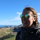
If you're looking for the best bang for your buck, Mount Storm King is your hike. With a short and steep trail that offers sweeping views of Lake Crescent and the Strait of Juan de Fuca, you won't be disappointed.
The trailhead is located right next to the Storm King ranger station adjacent to Lake Crescent right off Hwy 101 just past Port Angeles if heading West.
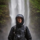
It shares the same trail as, and breaks off left from the Marymere Falls trail (also worth seeing) about a quarter mile in (look for signage). From there, the path wastes no time heading straight up for almost the entire way. The trail itself is very distinguishable and one need not worry about getting lost. After countless switches, you'll come to a viewpoint that offers partial views of Crescent Lake. At this point, you are getting very close to the top. After continuing on, you cross over a ridge that brings you to a series of ropes which you'll use to ascend to the top. After 4-5 sections of rope (the first of which seemed to be the most daunting), you make a short scramble to the top, where you'll be rewarded with sweeping panoramic views. Take time to eat some snacks and refuel before heading down, as you'll need as much energy as possible to descend back down the ropes and steep switchbacks.
Pro tip: for some great after-hike brews and food, head to Next Door Gastropub in Port Angeles.
Download the Outbound mobile app
Find adventures and camping on the go, share photos, use GPX tracks, and download maps for offline use.
Get the appFeatures
Mount Storm King Reviews
This hike is one of my favorite quick, high-reward routes on the Peninsula. The views from the top are really incredible, and very different from a lot of the popular hikes in the area. However, the fixed ropes that allow you to make it up the last .4 miles are NOT supported or maintained by the Washington Trail's Association. The "top" of the hike, according to WTA, is at 1.7 miles, which does not get you to the summit at 2.1 miles (or the spot where those amazing photos are taken). The fixed ropes are--according to rumor--removed by trail maintenance workers every once and a while for safety, and then replaced by the hikers who want to be able to reach the top. That being said, I have used the ropes plenty of times, and they have been fine...but remember to be careful and use them at your own risk.
4.0
Challenging hike, not for the dog or kids, but very well worth it for someone in good shape. The hike is actually 2.1 miles each way. Make sure to be careful at the top!
4.0

This hike makes Zion's Angels Landing look like child's play. Non stop climb all the way and just as you think you can climb no further, you have to grab onto the ropes to haul yourself up the final couple of pitches. But the view from the top is incredible. Be prepared to work hard and you'll be rewarded.
5.0
Leave No Trace
Always practice Leave No Trace ethics on your adventures and follow local regulations. Please explore responsibly!
Nearby

Marymere Falls

Kayak Lake Crescent

Spruce Railroad Trail

Camp at Fairholme Campground

Ancient Groves

Sol Duc Falls and Deer Lake
Community
Mobile Apps

© 2024 The Outbound Collective - Terms of Use - Privacy Policy