
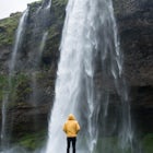
Crabtree Falls
Tyro, Virginia
Details
Distance
3.05 miles
Elevation Gain
1161 ft
Route Type
Out-and-Back
Description
Added by Lucas Moore
Explore Crabtree Falls, the largest cascading waterfalls east of the Mississippi River. This hike is great for both family and dogs, so bring the group.
This is an approximately 3 mile roundtrip hike. It will usually take anywhere from 1-2 hours to get up, depending on your experience and who you have with you, and about an hour down. As you come off of route 56, you will come up to the trailhead where there is a large parking area with restrooms. There is a $3.00 parking fee per vehicle that is on the honor system. You put your money into the container and take a pass to hang inside your car.
As the trail starts, it is paved for the first quarter mile or so as it comes to the first waterfall at the lower falls. It is a great place to go and see a waterfall without having to do much rough hiking. From here on out the trail is dirt meandering back and forth through the woods. It can get steep with some jagged rocks at some points and there can be places where the ice hasn't melted depending on the season you go in.
CAUTION: There are signs everywhere that tell you to stay on the trail and to not wander off near the falls because the rocks are very slippery. There have been plenty of deaths that result from it, usually one every couple years or so. I know that most people will wander off the trail, I do so myself, you pretty much have if you want any decent photos. I'm not advising it, but if you do be extra careful and know your limits.
Around 3/4 of a mile in you come the largest falls of the lower section that are over 200 feet! Then at a mile in, you reach the middle section of the falls, until about 1.5 miles where you get to the base of the upper falls. Then about the 2 mile mark, you reach the summit where you will cross a bridge and see a stone wall. There you have an awesome view of the Tye River Gorge. From there you can go back down the trail or continue on. There is Crabtree Falls Trail which has good campsites that continues beyond the waterfalls that goes for about 1.5 miles farther to reach Crabtree Meadows if you want to go farther.
Download the Outbound mobile app
Find adventures and camping on the go, share photos, use GPX tracks, and download maps for offline use.
Get the appFeatures
Crabtree Falls Reviews
I was really surprised at how close the parking lot is to the lowest section of the falls. Ideal if you want to quickly stop and take a few snaps but it's definitely worth hiking to the upper waterfall!
5.0

Great views the entire way up of the falls. Did it in about 2.5 hours which included lots of photo stops. Not technical or difficult. Good day trip!
4.0

Just completed this hike this morning with my wife, 10 year old son and dog. Thankfully we got out mid-morning and finished about lunch time. By the time we left the parking lot was packed and the trail was bumper to bumper. The falls were well worth the sometimes steep trek. Lots of picture opportunities.
4.0
Leave No Trace
Always practice Leave No Trace ethics on your adventures and follow local regulations. Please explore responsibly!
Nearby

The Priest via Shoe Creek Trail

Camp near Crabtree Meadows in GWNF

Spy Rock via Cash Hollow

Photograph 20 Minute Cliff Overlook

White Rock Falls Trail

Hike to White Rock Falls
Community
Mobile Apps

© 2024 The Outbound Collective - Terms of Use - Privacy Policy