
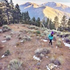
Cecret Lake from Albion Basin
Alta, Utah
Details
Distance
4.48 miles
Elevation Gain
1214 ft
Route Type
Out-and-Back
Description
Added by Colton Marsala
This longer hike to Cecret Lake offers up views of Devils Castle and Alpine Lake views. Amazing wildflowers, beautiful scenery and wildlife (lots of moose).
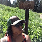
The out-and-back trail from Albion Basin to Cecret Lake climbs a gentle slope and along the way there are interpretive signs with information about the basin, its plants, animals and geology. From the lake you can return the same way you came, or explore the area more.
If you head there during the right season, it's a great opportunity to catch the wildflowers in bloom. I'd also suggest heading out to the lake later in the day so that you can catch the sun setting beyond the lake. If you're looking for a 2-mile out-and-back hike to Cecret Lake, check out this Cecret Lake adventure.
Remember that Cecret Lake is a protected watershed for Salt Lake City and swimming is not allowed. Please help keep Utah's watersheds clean.
Download the Outbound mobile app
Find adventures and camping on the go, share photos, use GPX tracks, and download maps for offline use.
Get the appFeatures
Cecret Lake from Albion Basin Reviews
The trail that leads to Cecret Lake has a ton of beautiful wildflowers all over the landscape in the late spring and summer. Cecret Lake is also a perfect place to hang out for the day and have a picnic.
5.0
We decided to do this hike right before having dinner in Little Cottonwood Canyon - very easy to do and Cecret Lake is a beauty. It's a small lake, but still very rewarding.
5.0
Incredible hike that takes you through meadow lands with breath taking views of the bluffs. The road that takes you to the trailhead that begins the 1.5 mile hike is open seasonally. We went before July 11th and was informed we would need to start at Albion Basin or walk along the road to the TH. This adds approximately an additional 2 miles each way. The hike is in no way strenuous and perfect for families with children. The only "rough" spot is right before you get to the lake, there are a few switchbacks and the rocks can be a little slippery. Just take your time getting up and down in this area. This is part of the watershed so no dogs are allowed, sorry.
5.0
Leave No Trace
Always practice Leave No Trace ethics on your adventures and follow local regulations. Please explore responsibly!
Nearby

Albion Meadows Trail

Spring Backcountry Ski Alta Ski Area

Mountain Bike Catherine's Pass

Backcountry Ski Grizzly Gulch

Milky Way Astrophotography At Alta

Snowshoeing Twin Lakes Pass
Community
Mobile Apps

© 2024 The Outbound Collective - Terms of Use - Privacy Policy