
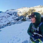
Munra Point
Cascade Locks, Oregon
Details
Distance
4.12 miles
Elevation Gain
1870 ft
Route Type
Out-and-Back
Description
Added by John Chau
Hike a unique three-ridgeline formation with lush views of the Columbia River Gorge. This hike is only 40 minutes away from Portland, Oregon.
This trail is temporarily closed. Please visit the Forest Service website for updates to trails in the Columbia River Gorge.
This hike starts at the Wahclella Falls trailhead, but does not use that trail. Instead, walk back towards the freeway and take a left onto the Columbia River Highway Trail. Go over the Tanner Creek bridge and take a left onto Trail #400. From here, follow Trail #400 until after the slight drop just before the freeway bridge over Moffett Creek. Here you'll see an unmaintained trail heading to the south. Head up it about 50 feet and you should see a trail sign saying "Trail Not Maintained."
Follow this trail as it steeply heads south, with Moffett Creek burbling in the distance to your right (west). The trail picks up in steepness once you get to a large rock wall to your left. Try not to cut the switchbacks that you will encounter! Eventually you will get to your first lookout that has a vertigo-inducing drop to the west. Stay on the trail and follow it all the way to the summit. After the scramble up to the tri-ridge summit, you'll be rewarded with a view of Table Mountain and Hamilton Mountain directly to your north, and Bonneville Dam and the Bridge of the Gods to your northeast.
Note:
- There is a $5 fee at the Wahclella trailhead (or buy a $30 Annual Northwest Forest Pass at a place like REI).
- Do not leave any belongings visible in your car due to numerous car break-ins.
- Do not attempt this hike during wet weather, since the rocks at the summit are extremely slippery and the runout severe.
- There is a parking lot, but spaces are limited
Download the Outbound mobile app
Find adventures and camping on the go, share photos, use GPX tracks, and download maps for offline use.
Get the appFeatures
Munra Point Reviews
Hey gang, for all future hikers who choose to conquer this scramble, PLEASE pick up your trash and any other trash that you might find out there. It's extremely disheartening to come back to a place that I love and find toilet paper, granola wrappers, and babywipes scattered around. Also, please do not carve your names, slogans, or anything whatsoever into the rocks along the northeastern ridge (or anywhere else for that matter). Thanks! -John Chau
5.0

I've hiked for many viewpoints at the gorge and this by far has the best view so far. It is extremely rewarding. I wouldn't say the hike is difficult for me since I am pretty fit, but going down really shot my knees a bit. Other than that, it was a fun climb to the top. It's comparable to dog mountain, but not as boring since you actually get to climb some rocks. Be careful though because there are drop offs, so don't go when it's even slightly wet. Also, it is a hike not for dogs if you ever plan on bringing your buddy. You can start at Wahclella Falls and backtrack to Tanner Creek and go from there, then turn left onto trail 400. You will be on trail 400 for a while, parallel with the highway and then there will be another left trail that leads you straight up to Munra Point.
5.0

It was more of a challenge than o expected, but well worth it. The view was outstanding!
5.0
Leave No Trace
Always practice Leave No Trace ethics on your adventures and follow local regulations. Please explore responsibly!
Nearby

Snow Hike to Wahclella Falls

Wahclella Falls

Ruckel Creek Falls

Backpack the Mark. O Hatfield Wilderness Via Eagle Creek

Metlako & Punchbowl Falls

Hike to Mossy Grotto Falls
Community
Mobile Apps

© 2024 The Outbound Collective - Terms of Use - Privacy Policy