
The 17 Best Mountain Bike Trails to Ride in Grand Junction, Colorado
Grand Junction, Colorado is an absolute mecca for mountain biking. Below are 17 of the best trails all adventurers need to check out.

Grand Junction, Colorado was recently ranked as one of the best outdoor adventure towns by the Matador Network, and after scouring Google Maps you will likely be able to see why. This exciting town in the heart of Western Colorado is surrounded by multiple unique natural features - including the Colorado National Monument and the Grand Mesa - many of which are home to many outdoor adventures like hiking, mountain biking, canyoneering and climbing.
While there are a lot of adventure opportunities to pursue in the Grand Junction area, in our opinion, what really makes this area stand out is its super fun mountain bike trails. From fast and flowy trails all the way up to super technical and steep routes, the mountain bike trails in Grand Junction really have something for every type of bike rider (including riders who are just getting into mountain biking).
Below you will find lots of helpful information about mountain biking in the Grand Junction area (including the best time of year to visit) as well as a list of the 17 best mountain bike trails to explore (plus five of our absolute favorites). So with that, let's get exploring!


THE BEST TIME TO MOUNTAIN BIKE IN GRAND JUNCTION, COLORADO
Spring and fall are by far the best times to mountain bike in Grand Junction and the rest of Western Colorado.
Between the months of April and May you can expect nice sunny days, temperatures in the mid-70s (around 22° C) and lots of wildflowers. In fact, even though we spent a spring season in Crested Butte, Colorado - the Wildflower Capitol of the state - we found ourselves just as in awe of the desert wildflowers near Grand Junction as we did in the mountains near Crested Butte.
Likewise, in the fall - especially during the month of October - you will find many trees in the Grand Valley have changed color; including, many of the large trees along the Colorado River. This is also the time of year when the temperatures start to cool down and nights begin to get a bit chilly.
During the winter (November - February) and summer (June - August) months, the temperatures are usually just a bit too harsh for mountain biking in Grand Junction. In truth, during the winter, snow is possible (though not very common) and the wind can make the somewhat manageable temperature feel even colder. Similarly, unless you are planning to ride early in the morning, the summer temperatures and intense sun exposure makes mountain biking a boiling and sweaty affair - especially since shade is hard to come by along many of the mountain bike trails.
❔ GOOD TO KNOW: while almost all of the Grand Junction mountain bike trails will be cleared of snow and have perfect temperatures by late April, you can unfortunately still expect a good amount of snow up in the Grand Mesa until late May and even into June. If you are looking to mountain bike up in the mesa, we suggest planning to do it in mid-June to early July.
WHAT TO BRING WITH YOU MOUNTAIN BIKING IN GRAND JUNCTION, COLORADO
Due to Grand Junction's rougher high desert terrain, you are going to want to come prepared with plenty of mountain bike gear - especially if you are planning to head out onto some of the more backcountry trails. Below are a few important things to have with you while mountain biking in Western Colorado.
Nothing ruins a day out on the trails faster than getting too much sun exposure (or worse, a sunburn). Therefore it is definitely recommended that you wear a shirt that helps block the sun's harmful rays (in Grand Junction the sun is extra intense due to the elevation). If planning to mountain bike in the area, make sure to wear a shirt that protects your full upper body - like this one by Backcountry. Plus, it's also a great idea if you are planning to ride some more technical sections for the long sleeves will also give your skin that extra layer of protection in case you take a tumble.
See our recommended sun shirt here.
Just like too much sun exposure can turn a great day out on the trails into a less than optimal experience, so can riding all day without proper paddy on your bum. Because let's be real, bike seats are not very comfortable and after 10+ miles on the saddle your booty will start to feel a little tender. Luckily, bike shorts can help curb some of this pain. This pair by PEARL iZUMi are comfortable, breathable and stylish.
See our recommended bike shorts here.
Many of the Western Colorado mountain bike trailheads do NOT have water available so you will definitely want to show up prepared - especially if you are planning to ride during the middle of the day when the sun is at its fullest or if you are looking to do a big ride. This water bladder and bag combo from CamelBak holds 9 liters of water and still has plenty of room to spare for stuff like snacks, extra layers and your phone.
See our recommended biking bag here.
This handy toolkit comes with everything you would need to fix all kinds of mishaps while out mountain biking in Grand Junction (or anywhere else for that matter). This lightweight toolkit can easily be stored in your biking bag or left in your car if you are only planning to do a shorter route.
See our recommended mountain biking toolkit here.
Another helpful thing to have with you while out mountain biking - especially on the more curvy mountain bike trails in Grand Junction - is a bike bell. This is just an easier (and slightly more courteous) way to let people know that you are coming down the trail. This one by Knog is simple and efficient.
See our recommended bike bell here.
Rounding out the list of things you should definitely bring with you while mountain biking in Grand Junction (and mountain biking in general) is a solid helmet that not only keeps your head safe, but is also comfortable enough to wear all day long. This one by Giro comes in a couple of fun colors, is very comfortable and lightweight and has enhanced breathability for when you start to climb and the sweat begins to pour down.
See our recommended mountain biking helmet here.

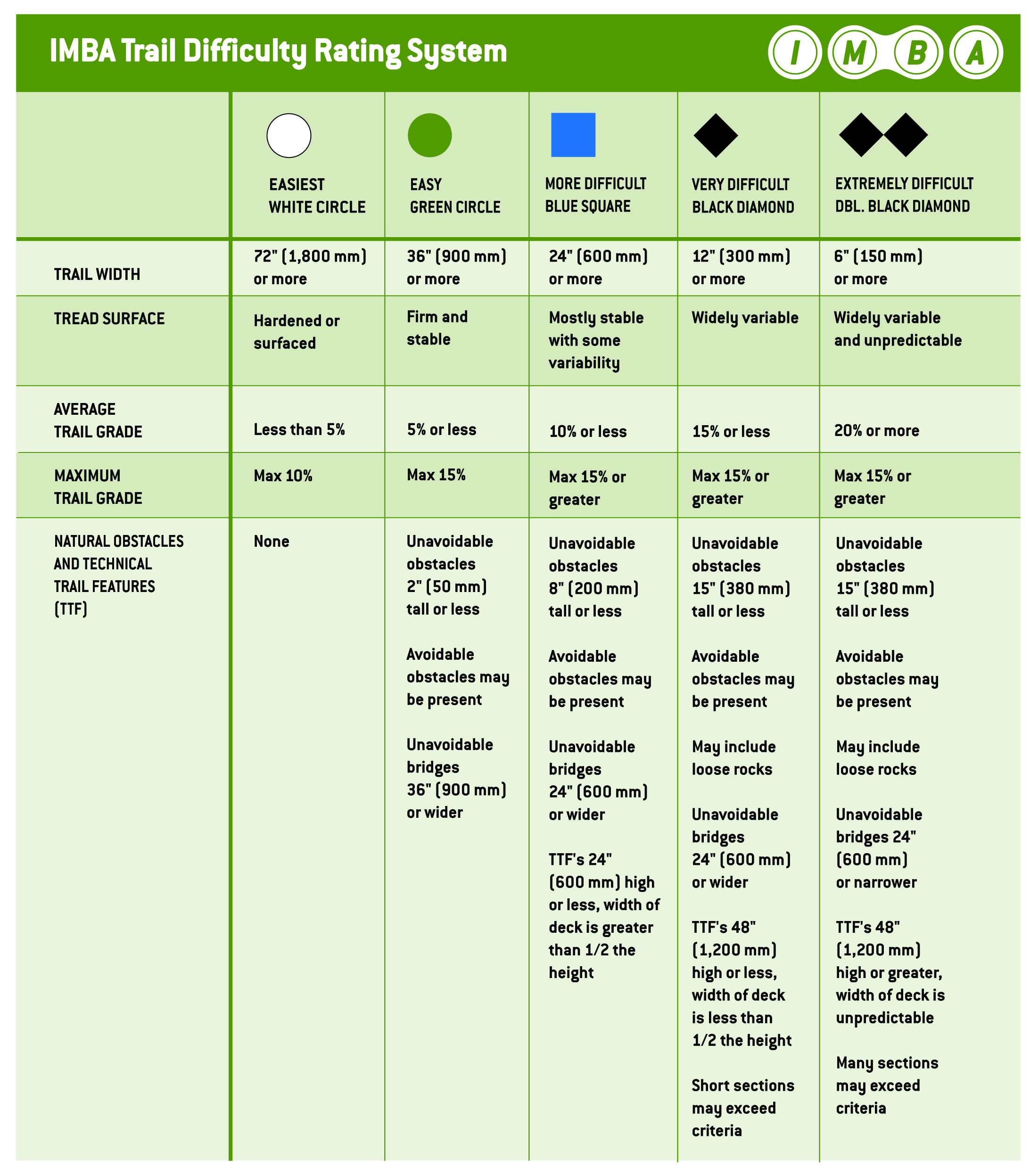
MOUNTAIN BIKE TRAIL RATINGS | WHAT TO KNOW
Just like with many other sports - most notably skiing or snowboarding - there is a clear difficulty rating system for mountain bike trails; in this case, the ratings are based on 5 things:
| Trail width| Tread surface | Average trail grade| Maximum trail grade | Natural obstacles and technical features
Below is a brief outline of what you can expect from each trail rating - which is super helpful to know if you are new to the sport and are trying to figure out what kind of trails you should do (or not do... yet). The trail rating information below is according to IMBA (or the International Mountain Biking Association).
Trails that are labeled as green circle will have 36" trail width, firm and stable surfaces, a 5% or less climbing grade and a max of 15% climbing grade. Also, you can expect some small unavoidable obstacles on the trail (like rocks and logs).
On trails that are labeled as blue square you can expect 24" trail width, mostly stable surfaces with some variability, a climbing grade between 10% and max of 15%, unavoidable obstacles that are max 8" tall and some natural bridges that you cannot avoid.
On trails that are labeled as black diamond you can expect 12" trail width, surfaces that are widely variable, a climbing grade at around 15%, some unavoidable obstacles that are max 15" tall and many loose rocks. Also, there is a likelihood of coming across multiple technical features that can be up to 48" high.
On these expert level trails you can expect routes with 6" trail width, highly variable and unpredictable surfaces, an average trail grade of 20% or more, unavoidable obstacles that are max 15" tall, many sections of loose rocks and unavoidable bridges that may be less than 24" wide. Finally, many trail sections can exceed this criteria and be even more technical (be prepared to test yourself).
Besides these four clear ratings, you may also find trails that fit between - like a trail that is rated Green/Blue, or more commonly, a trail that is rated Blue/Black.
➳ Find the full guide on trail difficulty ratings here.
THE 17 BEST MOUNTAIN BIKE TRAILS IN WESTERN COLORADO
\\ Kokopelli Trailhead
Maybe the most famous trail in the Grand Junction and Western Colorado area, the Kokopelli Trail system is a great spot to head to if you want to ride fun, flowy loops and get some stunning views of the surrounding area (including the mighty Colorado River). Plus, once you finish riding you are very close to the cute town of Fruita, home to many bike stores, cafes and the famous Hot Tomato Pizza restaurant.
Below are some of the best mountain bike trails that start at the Kokopelli Trailhead.
RUSTLER'S
3.9 mile loop | Green / Blue
This is a great beginner loop to explore if you are new to the desert terrain or if you are just getting into mountain biking in general. Plus, this beautiful and scenic loop also comes with lots of informative signs on the various plants and natural features in the area. We highly recommend this route if you are just looking to test the waters of mountain biking in Grand Junction.
| FULL BETA
HORSETHIEF BENCH
3.9 miles | Blue / Black
This is very likely THE ride you think of when planning to go mountain biking in Western Colorado. This intermediate loop is absolutely gorgeous and a whole lot of fun. If you only have time for one ride, this might be it.
There are two sections along the Horsethief Bench trail that are very technical and will likely require walking and carrying your bike (unless you are an absolute rock star). Besides those two sections, this scenic ride is actually quite beginner friendly and definitely worth doing even if you are not a hardened mountain biker. Just be prepared for some rocky sections and a few bumps here and there along the trail (and of course there is no shame in walking). Also, as you would expect with such a well-known trail, this loop does get very busy, especially in the right season and on the weekends.
| FULL BETA


MARY'S
5.6 miles (without the road) | Blue
This is a great mountain bike trail to ride if you are looking to combine a couple of loops (it connects to many other trails in the area) or if you want to do a bit of a bigger ride and avoid some of the crowds. To start the ride, head out on a rocky doubletrack road that climbs up to the rim (it's a bit of a tough start, but don't worry it's worth it!). Soon enough the trail levels out and you can start to get some speed going. Keep riding past a couple of other trails, including the famous entrance to Horsethief Bench, until it becomes a singletrack trail.
Mary's can be done as a loop ride by combining it with Wrangler (see trail description below) or with Hawkeye Road (which is a super wide and fast dirt road). If you choose the former, it is roughly 5.7 miles back to the trailhead, and if you choose the latter (Hawkeye Road) it is around 3 miles back to the trailhead.
💬 INSIDER TIP: if you are looking for a jam-packed, fun day out on the trails, consider doing Horsethief Bench and then ending with Mary's Loop (via the road). In total, this will be about 12.6 miles, much of which will be intermediate-level singletrack.
| FULL BETA
WRANGLER
5.7 miles | Blue / Black (upper)
This longer trail is actually split into two sections: the Wrangler North trail and the Wrangler trail. The first section, Wrangler North, is rated as a Blue/Black and is roughly 3 miles long. To reach this trail - which is known for its tighter switchback turns - you will need to head out on Mary's and then turn right onto the trail right before you reach the parking lot at the end.
The other trail, Wrangler, is a bit more popular and slightly less challenging (it is only a Blue). This mountain bike trail starts with a bit of a rocky climb before leveling out for some fun flat and fast sections. And because this tail is a tad higher than others in the area, you will get great views of the surrounding landscape. Ride the fun singletrack trail all the way back down to the main dirt road and either meet up with your car there or ride the dirt road back up to the main parking lot.
| FULL BETA ON WRANGLER NORTH & WRANGLER
Other great mountain bike trail options from the Kokopelli Trailhead area are the Kokopelli Loops, which is just under 19 miles and includes a combination of many of the trails mentioned above, and Rabbit Valley Loop, which is 13.4 miles total and rated as black (this ride is a bit further away from the others).

THE KOKOPELLI TRAIL
Of course we couldn't talk about the Kokopelli Trailhead and not mention the famous Kokopelli Trail :)
This stunning 143-mile ride takes you all the way from Fruita, Colorado over to Moab, Utah. The ride - which is usually done in 3-4 days - takes mountain bikers through deep canyons, across wide open desert plains and up some steep dirt roads. If you are looking for an exciting and adventurous bikepacking trip in the desert, then we highly recommend taking on this popular ride.
► You can explore our full guide on bikepacking the whole Kokopelli Trail here or watch our video on the trail here.
From Grand Junction, head west on I-70 for around 17 miles. You will get off at exit 15 (Mack/Loma) and then turn left. Keep driving until you see signs for the Colorado Port of Entry (DON’T TURN HERE). Take the dirt road that heads slightly left from the main paved road (there should be a sign). Keep driving until you see a parking lot with bathrooms and a big map. Park here OR keep driving up the dirt road that climbs up and over the ridge and then back down to park at the lower parking lot (this saves you a bit of biking time).
The start of the trail for Horsethief Bench, Rustler's and Mary’s are from this lower parking lot.
\\ Lunch Loops
Whereas the Kokopelli Trail system between is known more for its excellent flow with a few technical sections thrown in, the Lunch Loops are practically the opposite: expect very technical, loose and rocky trails with a bit of flow interspersed. If technical mountain biking isn't your thing, then the Lunch Loops trail system might not be the right spot for you. But, with that being said, if you do want to test yourself and your riding skills, then this is a great place to do it.
MIRAMONTE RIM
1.8 mile loop | Blue
This short loop is a great beginner trail if you are new to the Lunch Loops trailhead or the slopes of Western Colorado in general. To reach the start of the trail, you can either head out on Klunker via Little Park Trailhead (exact location here) or via the Big Sister - Time Machine - Leftover Lane trails, which start at the main trailhead parking lot.
💬 INSIDER TIP: the Miramonte Rim trail is a great ride if you are looking to get comfortable biking around rocky and somewhat slick terrain. It is also a somewhat popular trail running route, so always keep an eye out for people coming around the numerous tight corners.
| FULL BETA
MOTO
0.6 miles | Blue / Black
This is one of the many short connector trails that crisscross the Lunch Loops area. This one is especially fun thanks to its short but steep downhill sections and beautiful terrain (the last bit feels a bit like a rainbow Mars). To reach the trail, head out either on the Gunny Loop Trail or on either Miramonte or Coyote Ridge.
Other fun connector trails in the middle of the Lunch Loops are Raven Ridge and Pet-e-Kes.
| FULL BETA

THE GUNNY LOOP
12.1 miles | Black
Likely the most popular mountain bike trail at the Lunch Loops Trailhead, the Gunny Loop is a technical ride that takes mountain bikers from the main trailhead on either Eagle's Tail or Pet-a-Kes and up to the actual Gunny Loop (which is just over 6 miles long). Once you finish the Gunny Loop you can head back to the parking lot via Holy Bucket, Ali Alley and Curt's Ridge (all Blue trails).
This ride, though long in distance, is also quite technical. Be prepared for long climbs and steep descents - plus a lot of rocks and sharp turns.
| FULL BETA
TABEGUACHE TRAIL (GJ SECTION)
23 miles | Black
This 23-mile ride is actually part of a much longer and more challenging mountain bike ride that spans from the town of Montrose all the way across the Uncompahgre Plateau to Grand Junction. In total, this ride is 141 miles long and often takes riders 3-4 days to complete.
The Grand Junction section of the Tabeguache Trail actually starts right off of Highway 141 near the town of Whitewater (exact location here) before heading out on a mix of single track and double track trails. Along the ride, you will pass through pinyon and juniper forests and along rocky benches and canyons before making your way over to the Lunch Loops trail system. Once you reach this area you have the option to take numerous singletrack trails down to the Tabeguache Trailhead.
*A shuttle is required.
| FULL BETA
GJ Off-Road Grand 30 Route
29.7 miles, Blue / Black
Another exciting long-distance mountain bike trail in the Lunch Loops area is the Grand Junction Off-Road Grand 30 Route, which was actually the event course for the popular Grand Junction Off-Road race (hosted by Epic Rides) that happened every year until 2019. While the race no longer occurs in Grand Junction (though there is some talk of new organizers coming in and starting it back up) the challenging and scenic ride is still there - just waiting to be explored.
This ride starts and ends in downtown Grand Junction (perfect for grabbing a bite to eat or a coffee before or after the ride). From downtown, the route heads up to the Lunch Loops trail system and onto the Tabeguache Trail. This long mountain bike trail combines steep climbs, rough descents, challenging doubletrack and singletrack, and plenty of amazing views. Just make sure to bring plenty of water and snacks (and maybe a camera).
| FULL BETA
This trailhead, which is somewhat confusing since it is actually called the Tabeguache Trailhead (but it is also known as the Lunch Loops Trail System) is super close to downtown Grand Junction. To reach it, simply drive out on Grand Avenue until it crosses over the Colorado River. Now this road is called Broadway. Keep driving on this road until you see the turn for Monument Road on the left. Turn here and keep driving for another 1.7 miles until you see the Lunch Loops Trailhead and parking lot on your left.
💬 INSIDER TIP: if you are looking to spend a full day exploring and adventuring in Grand Junction, then we recommend mountain biking at the Lunch Loops Trailhead in the morning and then driving up into the nearby Colorado National Monument in the evening. You can find our full adventure guide on the Monument here.


\\ The North Fruita Desert
Located on the opposite side of the Grand Valley, this mountain biking area is popular for its fast downhill sections and close proximity to the unique Book Cliffs. Below are some of the best trails to ride in the North Fruita Desert area - from the easy to the intimidatingly difficult.
VEGETARIAN TO LOWER CHUTES
4.8 miles | Green
If you are looking to just test the waters of mountain biking out in the Fruita Desert (or with mountain biking in general) then this is a great trail to start out on. Measuring just under 5-miles in length, this loop includes a nice gradual climb at the beginning and then a super fun, flowy ride back downhill to the main parking lot.
| FULL BETA
PRIME CUT TO KESSEL RUN
4.2 miles | Green
Prime Cut (2.1 miles long) is a very nice gradual uphill ride that takes you through juniper pinyon forests and across a couple of dry gullies. One you finish riding Prime Cut, turn left onto Frontside Trail until you reach a small parking lot. Then start riding Kessel Run - which is a great swoopy and fast downhill trail - all the way back to the parking lot where you started.
| FULL BETA

CHUTES AND LADDERS
6.9 miles | Blue / Black
This long loop is a great trail to take on if you are looking for a serious workout. To start, head out on Prime Cut - which is a nice gradual ride up to the actual start of the Chutes and Ladders Trail. Once you reach the main intersection, head straight and start a couple of grueling (but luckily short) climbs interspersed with equally steep downhill sections (hence the name chutes and ladders).
Eventually, the trail starts to even out and you can really start to pick up speed. Along the way you will come to a couple of other trails, including Vegetarian. If you are looking for the fastest and most flowy trail, stay left until you reach the Edge Loop Trail. Take this and prepare to gain some speed.
| FULL BETA
ZIPPITY DO DA
2.4 miles | Black
While this is a bit of a shorter trail, Zippity Do Da is definitely one of the more intimidating rides in the area. That is mostly due to two things: some seriously steep and slick drops and narrow trails along even narrower ridgelines. While this trail is not really that technical - there aren't very many rocky sections - what makes it so challenging is just the fact that it is very much up and down, and the downs are veeeery steep.
To reach the Zippity Do Da trail, either bike up or drive to the "upper" parking lot and then ride out on the Frontside Trail (rated as a Blue / Black). Once you finish riding the Zippity Do Da Trail, you will be very close to the lower parking lot (the main lot). Another fun option is to combine riding Zippity Do Da with the much larger Zippity Loop, which is 8.5 miles total.
| FULL BETA
THE EDGE LOOP
29.1 mile loop | Black
If you want a truly epic and challenging mountain bike ride, then the nearly 30-mile long Edge Loop might be the route for you.
Soon enough you will start a fun descent back down - though be aware of one quite technical section (see below). Just keep riding the Edge Loop until you meet back up with some of the other trails in the lower sections, including Chutes and Ladders. Eventually, the loop spits you out right back to where you started in the lower parking lot.
❔ GOOD TO KNOW: there are two important things to know about this trail before you head out to ride it. First, this trail heads deep into the Book Cliffs, an area that is dry and rugged (and hot during the summer months). Come prepared to be totally self-sufficient, for help can be hard to come by. Secondly, this mountain bike loop actually includes a 50-foot rappel. Yes, you read that right. While there is also the option to hike-a-bike around this section, we recommend bringing some ropes and seeing how it goes (all for the adventure right?!).
| FULL BETA


DIRECTIONS TO THE NORTH FRUITA DESERT TRAILHEAD
From Grand Junction, head west on I-70 until you get to the town of Fruita (around 13 miles away). Turn right off the interstate and then turn right again onto Aspen Avenue. At the large roundabout, keep going around until you see Mesa Avenue. Turn here and then keep driving until you get to 17 ¾ Road. Turn right and then take an immediate left onto 17 ½ Road. Drive north on that road until you get to N 3/10 Road. Turn right on this road and then left on 18 Road. This is (finally) the road you will drive all the way out on until you reach the parking lot for the biking trails (around 8 miles away). 💬 INSIDER TIP: after riding all day, make sure to stop off at Hot Tomato Pizza for a delicious slice of pizza and some local beer. The restaurant is located right in downtown Fruita. Find the exact location here (and also in our interactive map below).
\\ The Grand Mesa
While Grand Junction and most of Western Colorado are known to have more desert-y style mountain bike trails, there is in fact an area you can head to that swaps out dry riverbeds for large mountain lakes and cacti for aspen trees. Known as the Grand Mesa, this stoic natural structure is actually the largest flat-topped mountain in the world. The mesa stretches 40 miles wide and contains over 300 lakes. While mountain biking is a great way to explore the area, other popular outdoor adventures include hiking, camping, ATV-ing, cross country skiing and driving the scenic byway from Palisade to Cedaredge.
LANDS END ROAD
24 miles | Blue
While this is not much of a mountain bike ride - in the sense of it being almost entirely on nice dirt roads - it is still a fantastic ride if you are looking to strengthen your legs and your lungs. This intense uphill ride begins at the base of Lands End Road where the sidewalk ends and the dirt road starts to climb steadily. Keep riding up the many (many) switchbacks for around 10 miles until you reach the top of the Grand Mesa. From there you can either stop and turn around for a fast descent, or continue riding on the dirt forest road for another 10+ miles until you reach Highway 65. Once you reach the highway you can turn around and do the route backwards or ride out on Highway 65 towards either I-70/Palisade or to Cedaredge on Highway 65.
💬 INSIDER TIP: this road is a somewhat popular summer route up and down the mesa, so be prepared to share the road with vehicles - especially if you are riding on the weekends.
| FULL BETA
FLOWING PARK LOOP
15.2 miles | Blue
This flowy loop affords riders lots of fun and outstanding views of the Grand Mesa. Plus, due to its more laid-back, non-technical style, the trail is a great route for beginner riders looking to test their fitness.
To reach the trailhead of the Flowing Park Loop, head out on Lands End Road until you see the turn for Flowing Park Road (109) on the left. Keep driving until you get to the trailhead near Flowing Park Reservoir. From the trailhead, the trail heads out and makes a lollipop shape. Though there is also the option near the halfway point to ride out on the Indian Point Trail, which is also a blue.
| FULL BETA

PALISADE PLUNGE (COMPLETE RIDE)
32 miles | Black
This outstandingly beautiful ride takes you from the top of the Grand Mesa, across stunning high desert and forest scenery and then all the way down some steep rocky descents to the cute town of Palisade. Along the way, riders will pass mountain lakes and plenty of awesome views of the surrounding landscape - including the towns of Palisade and Grand Junction, the Book Cliffs and the Colorado National Monument.
The trail, though 32 miles in length, is mostly flat or downhill (in total, you only climb up 839 feet - but you drop 6,814 feet). To reach this exciting mountain bike route, head up to the top of the Grand Mesa on Highway 65 until you reach the Mesa Top Trailhead. From there, start riding out on a singletrack trail that almost parallels the Lands End Road. Once you reach the Shirttail Point Trailhead (around mile 12) the technical, downhill drops begin. Keep riding through open desert, aspen forests and along rocky rims until you eventually (20 miles later) make it to the Palisade Rim Trailhead.
💬 INSIDER TIP: when done riding in Palisade, consider heading out to explore some of the town's famous orchards and vineyards (and cideries!). We recommend stopping in at either Talbot's Cidery or Varaison Vineyards & Winery.
| FULL BETA
| PLUNGE TO POWDERHORN
Another fun option if you aren't looking to do the full 32 mile Palisade Plunge ride is to start out at the same trailhead as above and then ride out on the singletrack trail for six miles before turning onto the Deep Creek Trail. From there, you will get to ride a couple of forest roads and singletrack trails until you reach the start of the Powderhorn Bike Park. In total, this fun ride is 16.8 miles long. You can find the full route beta here.
❔ GOOD TO KNOW: if you want to ride at the Powderhorn Bike Park, then you need to first sign a waiver. You can do this at the check-in booth that sits along the trail.
| PALISADE PLUNGE - MESA TOP
This is just the first section of the much larger Palisade Plunge ride. This trail is 12 miles in length and rated as green. If you are just looking for a beautiful ride atop the Grand Mesa, this might be the trail for you. Find the full route beta here.
*Shuttle required for the complete Palisade Plunge Trail and the Plunge to Powderhorn Trail. If you want to hire a shuttle for the rides, consider booking through Rapid Creek Cycles. You can find their rates here.
Many of the mountain bike trails up on the Grand Mesa start or end near Lands End Observatory and the Mesa Top Trailhead. To reach either, first start out by driving up the Grand Mesa Scenic Byway (Highway 65), which you can reach off of I-70 roughly 18 miles east of Grand Junction. Once on the scenic byway, you will keep driving up and up, through the town of Mesa and past Powderhorn Ski Resort, until you see signs for Lands End Observatory and the Mesa Lakes Trailhead (it's about 25 miles from the interstate).
The Lands End Road is dirt, but it is well-managed and pretty easy to drive on (even without a 4x4 car). The Mesa Top Trailhead is just past the turn-off for Lands End Road and should be easy to find (there are signs and a big parking lot).
❔ GOOD TO KNOW: if you are looking for a more adventurous drive to the trailhead and you have a vehicle that can handle steep, rocky switchbacks, then consider driving UP Lands End Road from the base of the Mesa. This route is just under 22 miles (one-way). To reach the start, head south out of Grand Junction on Highway 50 until you see the turn for Kannah Creek Road (on the left). Drive up this road until it turns into Lands End Road.

OUR TOP 5 MOUNTAIN BIKE TRAILS IN GRAND JUNCTION
While there are a whole lot of trails to explore in and around Grand Junction, we have narrowed it down to what we believe are five of the best. So if you are short on time, definitely consider putting these five trails near the top of your adventure itinerary.1 | Horsethief Bench
2 | Mary's
3 | Gunny Loop
4 | Zippity Do Da
5 | Rustler's
Western Colorado, and Grand Junction in particular, is one of the best places in the country to head out on a grand mountain biking adventure. These 17 routes above are definitely some of the best mountain bike trails in Grand Junction and therefore they should 100% be on every mountain biker's must-do list.
If you have any questions about mountain biking in Grand Junction or Western Colorado in general - or if you just have questions about mountain biking and adventure travel - then please leave us a comment below or reach out to us directly.
Happy adventuring!
We want to acknowledge and thank the past, present, and future generations of all Native Nations and Indigenous Peoples whose ancestral lands we travel, explore, and play on. Always practice Leave No Trace ethics on your adventures and follow local regulations. Please explore responsibly!
Do you love the outdoors?
Yep, us too. That's why we send you the best local adventures, stories, and expert advice, right to your inbox.


