
Sawtooth Lake via Iron Creek
Stanley, Idaho
Details
Distance
10.04 miles
Elevation Gain
1962 ft
Route Type
Out-and-Back
Description
Added by Dusty Klein
Sawtooth Lake via Iron Creek takes you through unrivaled Idaho scenery, with the iconic jagged mountains. Camp on a beautiful alpine lake with various day hikes from camp.
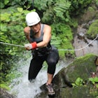
Sawtooth Lake is "must-see" for Idaho hikers or any outdoor enthusiasts visiting the Sawtooth National Forest. The five mile trek to the lake is made worthwhile by breathtaking, photogenic alpine lakes and the crisp, clean Idaho air. It's up to you whether to day hike the trail or to camp at the destination, but one thing is for certain: don't forget to bring your camera!
From Boise, take Hwy 55 to Banks, where you'll hang a right and head on Banks Lowman Road for 33 miles along the South Fork of the Payette River. Once you reach Lowman and a T in the road, take a left and cruise 55 miles until you approach Stanley. Once Stanley comes into view, be on the lookout for Forest Road 619, it's about a mile before the small town. Turn right on to a gravel road and follow it the last 2-miles-and-change to the trailhead. There is a campground and other various camping spots at the base of the Iron Creek Trailhead if you plan on coming up after work and camping, or just want to get an early start the following day.
Be sure to fill out a free Sawtooth Wilderness permit at the trailhead and drop it in the box. There is also a map of the region here if you want to get a visual on the upcoming hike. Although you will see others on the trail, understand that this area is fairly remote. Pack a first aid kit even if it's just for peace of mind.
The first part of the journey is quick and pretty. You'll travel along the first couple of relatively flat miles with glimpses of Iron Creek. Whip your camera out about a mile and a half in; an unbelievable view of the water flowing through a meadow, contrasted by towering mountains will make your friends wish they had brought theirs too. Following the sign ahead, remain left and continue for another mile or so of mild hiking until the switchbacks begin.
Four miles from the trailhead, you'll see a sign pointing to the left for Alpine Lake. About a quarter mile off of the trail, this is a gorgeous high mountain lake that doubles as a pristine lunch spot. This lake is camp-able and will see less hiker traffic than Sawtooth Lake but is simply a "little sister" to our final destination. Get ready for the last mile climb, as it's the toughest, steepest stretch of the journey. As you climb the switchbacks, look back over Alpine Lake for some spectacular views. From that high you'll be able to see straight to the bottom of the undisturbed water below.
As the trail flattens out and you approach Sawtooth Lake, you'll be greeted probably by a few patches of snow on the ground (yes, even in summer months) and by a small lake with creeks flowing into it. Don't be fooled, you're not there yet. Follow the creeks and the path upstream. Cross over the creeks by shifty log bridges and once Sawtooth Lake comes into view, there's no mistaking it by its size and shear beauty. Mt. Regan, the tallest of the Sawtooth Mountains, protrudes from the opposite end of the lake and will undoubtedly be the focus of many of your landscape photos.
If you're backpacking, you've got options. You can 1) camp near this log jam around where you approached the lake, 2) cross the jam and search for camp spots along the lake, or 3) continue right to extend your journey to other lakes deeper within the mountains.
This region is very cold and requires warm clothing even in the summer months. The contrast of warm days and cold nights is a unique challenge for backpackers. In addition to day hiking, star gazing and taking pictures along the way, you can also try your luck with a fishing pole. The water is so clear that you can actually see the trout bite on the hook. We spent hours catching and releasing 6-8" fish with a fly rod on our last trip to the lake. Pack light, but be sure to pick up a license before the trip if you do plan on fishing.
The hike to the lake takes about two and a half to three hours, while coming down takes significantly less time and effort. As always, be sure to pack out what you packed in and leave your camp spot in better condition than what you found it. This region in Idaho is notorious for forest fires. Before embarking on this trip, check with the local Ranger Station to make sure it is safe and that you'll have a smoke-free trip.
Download the Outbound mobile app
Find adventures and camping on the go, share photos, use GPX tracks, and download maps for offline use.
Get the appFeatures
Sawtooth Lake via Iron Creek Reviews

Great review of a great trip! A reminder to anyone going for the first time, I wouldn't even attempt to camp at Sawtooth Lake before mid-July. Many years, 4th of July weekend will still find the entire lake covered in a foot of snow.
5.0
Great description! One of my favorite Sawtooth Lakes!
5.0
Great description, and great trip! We loved our overnight trip.
5.0
Leave No Trace
Always practice Leave No Trace ethics on your adventures and follow local regulations. Please explore responsibly!
Nearby

Goat Lake via Iron Creek

Raft Down the Salmon River

Photograph the Sawtooth Mountains

Photograph McGowan Peak & Stanley Lake at Sunrise

Paddle on Stanley Lake

Hike from Stanley Lake to Bridal Veil Falls

Visit Idaho
Idaho is a picturesque state filled with beautiful scenery and warm, wonderful people. It's an ideal destination for family travelers, outdoor enthusiasts, adventure seekers, or those just looking for a relaxing getaway.
Learn MoreCommunity
Mobile Apps

© 2024 The Outbound Collective - Terms of Use - Privacy Policy