
Danielle Tourigny Explorer
Maine resident and Emergency Medicine PA-C with a love of all things nature. Traveling around to find the most beautiful spots and most delicious eats.

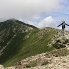
Hike up to Maiden's Cliff
Camden, Maine
2 mi
/ 1000 ft gain
With a total elevation gain of 1000 feet in one mile to the top, the entire hike is uphill. The whole hike is within tree line until the very top, but there is a beautiful stream to hike next to for at least half. At the top, the view opens up to the Maiden's Cliff, and the view is spectacular. The one mile back is not difficult, but if you hike it in winter, it can get pretty icy, so be carefu...

Hike Borestone Mountain
Guilford, Maine
3.6 mi
/ 2000 ft gain
Important notes about this hike:
REQUIRES A FEE: $6 per adult, $3 per student - they don't collect the fee until you get to the visitor center about a mile in, so don't get caught like I did without cash!Does NOT allow dogs.
Drive towards the Audubon Sanctuary and come to a parking lot just outside the gate.
The Base Trail begins just beyond the gate at the trailhead next to a kiosk. The trail...

Off-season Camp at Blackwoods Campground
Mount Desert, Maine
0.75 mi
When we saw that the weather in Acadia was going to be mid 40's and sunny in March, we decided we had to go. However, when you go in March there are a lot of different things about Acadia National Park that are helpful to know.First of all, it is recommended that you camp at Blackwoods Campground if you are planning on camping. The road into the campground is closed though, so plan on backpacki...

Snowshoe to Carter Notch Hut
Gorham, New Hampshire
7.8 mi
/ 2200 ft gain
The nineteen mile brook trail is a winding path up approximately 2200 feet of elevation over the course of 3.9 miles. That distance feels a lot farther when you are breaking trail in 18-24 inches of snow and you are carrying 35 lb packs on your backs. Luckily we started out early and we able to get up to the hut in the very early afternoon. Much of the trail follows along a river and after a f...

Photograph Sunrise at the Old Orchard Beach Pier
Old Orchard Beach, Maine
5.0
Few things create a more dramatic scene for a sunrise than a pier spanning out into the water, and the one in Old Orchard Beach is pretty iconic. Normally the area is pretty packed, and it can be tough to find a parking spot (especially in the summer). But at sunrise, there is just you, the beach, and that one old guy walking his dog around. I spend the night before looking at the weather. The ...

Summit Mount Waumbek via the Starr King Trail
Jefferson, New Hampshire
5.0
7.2 mi
/ 1500 ft gain
The hike starts out at the Starr King trailhead because you will summit Starr King Mountain (3,907 ft - so close to being a 4000 footer!) before moving on to Waumbek. The 2.6 miles that it takes to get to the first summit are gradual and forgiving. The majority of the total elevation is completed during that time. The first 1.5 miles is through tall spaced out trees that let the sun shine throu...

Hike Tumbledown Mountain
Weld, Maine
5.6 mi
/ 2300 ft gain
To keep the hike as short as possible, the hike can be an out and back at 5.6 miles, but if you wanted to make it a loop that is possible and adds only an additional 2 miles or so. We took the Brook Trail up to the summit (which passes by the alpine lake) and then followed it back down. To hike the loop, continue driving down Byron Rd to the second parking area to take the Loop Trail up. You wo...

Winter Hike up Mount Lafayette
Franconia, New Hampshire
9 mi
/ 3900 ft gain
To start this hike, you can park right at the trailhead in a parking lot off of 93. This is a hike up a mountain so the entire hike is pretty challenging. There is a total elevation gain of 3900 feet in about 4.5 miles. A couple miles in you break through the treeline and then from there the views are incredible. There is a ridgeline to walk along and you have a great view of the summit of Lafa...

Hike the Roque Bluffs State Park Loop
Roque Bluffs, Maine
2.1 mi
/ 187 ft gain
There are several short trails within the park that loop upon each other, so there are several different routes you could take. We chose the Houghton's Hill trail (which is a total of ~1 mile) and looped up with Pond Cove trail (also ~1 mile) by taking Millhill trail. The entire loop ended up being just over 2 miles. The trail is fairly flat and winds through several birch groves and pine fores...

Kayak Casco Bay
Portland, Maine
4 mi
This kayaking adventure begins at East End Beach at the Eastern Promenade in Portland. There is an easy boat launch zone if you have your own sea kayaks, but if you need to rent, Portland Paddle is right at the launch zone! It is $45 for 2 hours with a tandem sea kayak, which is what we opted for.If you are not familiar with sea kayaking or how to a recover a capsized kayak, it is best to stay ...

Hike the Mt. Moosilauke Glencliff Trail
Warren, New Hampshire
5.0
7.1 mi
/ 2454 ft gain
To get to the trailhead, take the 25N, turn right onto High Street and continue along this road until it comes to an end. The Mt Moosiulauke Glencliff Trail takes you through seven miles of forest and mountain scenery. The trail features impressive vistas and eye-catching wildflowers, which might even help you take your mind off the elevation gain. This particular trail is lightly trafficked, m...

Hike Paradise Park
Government Camp, Oregon
5.0
12 mi
/ 2300 ft gain
The hike begins at Timberline Lodge, which sits on Mount Hood at 6,000 feet of elevation. Find the Timberline trail behind the lodge by following any of the maze of trails heading east and you will be on your way! After 1.2 miles, you reach Little Zigzag Canyon where you will descend approximately 1000 feet to reach the bottom before heading straight back up again. This portion of the trail is ...

Snowshoe Mount Pierce
Crawford Notch Road, New Hampshire
6.4 mi
/ 2500 ft gain
The hike begins right across from the AMC Highland Center, which is great because you can utilize their spacious parking lot! Once you locate the trailhead, the elevation begins almost immediately. Begin on the Crawford Connector Trail for 0.4 miles.You will come to a foot bridge over Gibbs Brook, where there are beautiful cascades to look at. Just after you cross the bridge, follow the signs v...

Hike Mt. Carrigain
Bartlett, New Hampshire
5.0
10 mi
/ 3250 ft gain
Park on Sawyer River Road at the Signal Ridge Trailhead. Trail starts out as a mild climb and meanders with the Whiteface Brook. When you arrive at the Carrigain Notch Trail junction, turn left. Enjoy three miles of steep uphill along the mountain's edge. When you reach the the apex of Mt. Carrigain, take your time to enjoy the moment of rest and take in the surrounding wilderness. When you've ...

Hike Southern Middlesex Fells Loop
Medford, Massachusetts
4.7
3.5 mi
/ 756 ft gain
Park in the parking area near Bellevue Pond. There are multiple entrances to the reservation (some closer to the reservoir itself than others). I have spent days in there hiking around and never seeing the water and there are days when I just hiked right in to the water and sat and enjoyed it. The trails are perfect for mountain biking as well. I spent so much time here when I lived in Boston b...

Summit Bald Peak and Mt. Pleasant
Denmark, Maine
6 mi
/ 1450 ft gain
After turning on Mountain Rd, look for East Pinnacle Condominiums. The trailhead is about 0.1miles after that on the right between the telephone poles marked 49 and 50. There is a dirt parking lot to pull into.
Now on to the hike! This hike begins by heading straight uphill immediately, and you gain about 1,300ft of elevation in about 1.5miles. The signs say that it is a mile up, but my GPS tr...

Photograph West Quoddy Head Lighthouse
Quoddy Head State Park, MaineWe started our adventure in this area by backpacking the Cutler Coast (adventure to come on this)! After our night in the backcountry we drove 20 minutes to the adorable town of Lubec. At West Quoddy State Park, you are able to walk around the cliffs to get views of the Canadian border and see the brightly colored lighthouse that is a photographer's dream against a cloudy backdrop.
We stopped ...

Snowshoe the Northern Loop Trail at Bradbury Mountain
Pownal, Maine
2 mi
/ 407 ft gain
Bradbury mountain has ample parking and multiple trails that lead around the mountain and up to the summit. We took the Northern Loop, which is the longest trail up the small mountain. It is a gradual incline of 407 ft over 1.0 mile. It is a perfect out and back trail just to get outside for a bit and give the snowshoes some use. The trails at Bradbury State Park are well groomed and perfect f...

Backpack to Katahdin Lake
Baxter Park Road, Maine
3.0
6.6 mi
/ 0 ft gain
This hike is located in Baxter. Maine residents gain free admission into the park; non-residents must purchase a day pass ($14 per vehicle) or season pass ($39 per vehicle).
After entering the park at Togue Pond Gate of Baxter State Park, bear right and continue onto the Roaring Brook Road for 6.3 miles to the Avalanche Parking Area on the left. The trailhead for Katahdin Lake Trail is across t...

Hike Cathedral Ledge
Bartlett, New Hampshire
4.0
3.4 mi
/ 722 ft gain
During spring, summer and fall there is a road that allows you to drive to the top of Cathedral Ledge. In winter the road is closed off to vehicles so reaching the top requires a 1.7 mile hike. Once at the top, there is a fenced in lookout with a 180 degree view of North Conway and the surrounding mountains. There is also a gorgeous aerial view of Echo Lake. Cathedral Ledge also has a plethora ...
Community
Mobile Apps

© 2024 The Outbound Collective - Terms of Use - Privacy Policy