
Alex Seger

Blue Sky Ecological Reserve to Ramona Dam
Poway, California
3.0
5.3 mi
/ 984 ft gain
Starting at the trail head where you park your car, head south along the Green Valley Truck Trail. After less than a mile, you will notice the city and noise start to fade behind you, and a beautiful sight of towering oaks, willows, and sycamores appear as you walk along the Creekside Trail. You will see a brown sign signaling you to veer left for this trail. Enjoy the feeling of entering a com...

Crystal Cave
Santee, California
4.0
0.46 mi
/ 59 ft gain
Starting at 8100 Mesa road, you will see parking along the side of the road in a few places, take advantage where you find it.
Pass over the trail gate that marks the start of the journey. This will be a quick trip, as the total distance is less than a mile out and back. Head a quarter mile or so before you come across a waterfall and small pond on your right hand side. Depending on the time ...

Hike around Goodan Ranch
Poway, California
5.0
3 mi
Starting at the Sycamore Canyon Trail head, you will see the sign and gate that leads to Goodan Ranch. Head down the gravel road for 1.1 miles, until you reach a 3-way directional split. Heading straight for another .5 miles will take you directly to the ruins of the old Goodan house. Here you will find bathrooms, shaded resting areas, and water fountains. The visitor center, when open, has som...

Explore the Sutherland Dam
Ramona, California
2.0
1 mi
Once your on Sutherland Dam Rd, follow it until your right next to the dam. Park on the side of the road where you see a small turn-out. Walk down to the side of the dam and drop down onto the concrete flooring of the dam. Walk on-top where allowed, and check out the views of the lake and the mountains. Next you can walk the gravel road around and down to the bottom of the dam. From here, feel...

Explore Chambers Hidden Dam and Waterfall
San Diego, California
3.2
0.5 mi
Once you get off on Poway road, turn right onto Sabre Springs Parkway. Take your immediate left onto Creekbridge Road and park right there on the hill. Walk straight down towards the black gate and go down the hill. Turn right on the trail and walk down 1/4 mile to the dam, and another 500 yards to the waterfall! You will see a tiny break off to the left that leads to the dam. Hop up on the wal...

Hike the Oakoasis Open Space Preserve
Lakeside, California
2.5 mi
/ 300 ft gain
Starting at the trail-head, head down towards the oak-lined ravine marking the beginning of the hike. With trees already growing back from the 2003 fire, these sections of the trail are nice and shady, and quite relaxing. About 1 mile in you will start to see the San Vicente Reservoir to your left. Take the 'Scenic Overlook' trail that veers left for 200 yards or so and takes you to a breathta...

Oak Canyon in Mission Trails Regional Park
Santee, California
5.0
3.22 mi
/ 249 ft gain
Starting on Father Junipero Serra Trail, drive 0.7 miles west to the Old Mission Dam parking lot on the left. The park closes the gates at 7pm, so make sure to park early, or plan your hike in such a way that you don't get locked in! If you think you'll need longer, you can park out on the main road, and walk in.
Starting at the parking lot, walk down past the bathrooms to the entrance for Oak...

Cowles Mountain via Big Rock Road
Santee, California
4.5
4.32 mi
/ 1109 ft gain
Start by plugging 8125 Arlette St, Santee, CA into your GPS. This takes you to Big Rock Park, a convenient parking spot for the Cowles Hike. From here you want to walk through the park, and around the right side of the tennis court. This will take you to the fenced entrance to the hike. Head south for about a half mile( residential houses will be on your left for this small stretch) then link u...

Black Mountain via Nighthawk Trail
San Diego, California
5.0
4.05 mi
/ 764 ft gain
Starting at the trail head at the end of Oviedo way, you will see a power line on top of the small hill across from the rec center, which is the start of the South Point View Trail. Follow this trail about a mile until you see a sign for the 'Little Black Mountain Loop' . This is a 4.1 mile loop around the peak of the mountain offering stunning views and peaceful spots for relaxation. Head righ...

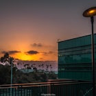
Catch a Sunset at Twin Peaks Mountain
Poway, California
2 mi
Start by parking at Silverset Park. You will see the trail head for Twin Peaks just behind the park. Park outside of the park if you think you'll be staying past sunset, as the park gates close at dark! Once you spot the trail head, veer left to the path heading up towards the peaks. You will eventually get to a fork in the trail. Heading left takes you on a more moderate ascent to one of the p...

Catch a Sunset at Lake Murray
La Mesa, CaliforniaLake Murray Reservoir provides drinking water to parts of San Diego, and thus is a no swimming lake. This is one of the reasons it is such a great place to photograph! If you are shooting the sunset, use this app to check the time the sun sets, and get to the lake at least 30 minutes prior to set up your scene. I like to spend ten minutes or so searching for a great vantage point. The beauty of...
Community
Mobile Apps

© 2024 The Outbound Collective - Terms of Use - Privacy Policy